Géolocaliser

Carte topographique Hythe

Carte interactive

Cliquez sur la carte pour afficher l’altitude.

À propos de cette carte

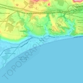
Nom : Carte topographique Hythe, altitude, relief.

Lieu : Hythe, Folkestone and Hythe District, Kent, England, United Kingdom (51.04664 1.02214 51.08961 1.12895)

Altitude moyenne : 32 m

Altitude minimum : -2 m

Altitude maximum : 165 m

Autres cartes topographiques

Cliquez sur une carte pour visualiser sa topographie, son altitude et son relief.

Folkestone

United Kingdom > England > Kent > Folkestone and Hythe District

Folkestone, Folkestone and Hythe District, Kent, England, United Kingdom

Altitude moyenne : 62 m

Park Gate

United Kingdom > England > Kent > Folkestone and Hythe District > Elham

Park Gate, Elham, Folkestone and Hythe District, Kent, England, CT4 6BH, United Kingdom

Altitude moyenne : 130 m

Lympne

United Kingdom > England > Kent > Folkestone and Hythe District

Lympne, Folkestone and Hythe District, Kent, England, United Kingdom

Altitude moyenne : 56 m

Littlestone on Sea

United Kingdom > England > Kent > Folkestone and Hythe District > New Romney

Littlestone on Sea, New Romney, Folkestone and Hythe District, Kent, England, TN28 8QU, United Kingdom

Altitude moyenne : 1 m

Densole

United Kingdom > England > Kent > Folkestone and Hythe District

Densole, Folkestone and Hythe District, Kent, England, CT18 7BE, United Kingdom

Altitude moyenne : 146 m