
Faire un don
Équipez-vous pour votre prochaine aventure :
En tant que Partenaire Amazon, ce site perçoit une commission sur les achats éligibles sans surcoût pour vous.
Carte topographique Franklin Mountain
Cliquez sur la carte pour afficher l’altitude.
Faire un don
Équipez-vous pour votre prochaine aventure :
En tant que Partenaire Amazon, ce site perçoit une commission sur les achats éligibles sans surcoût pour vous.
À propos de cette carte
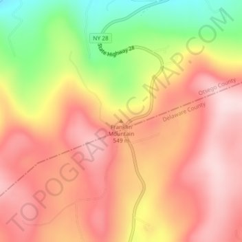
Nom : Carte topographique Franklin Mountain, altitude, relief.
Altitude moyenne : 533 m
Altitude minimum : 342 m
Altitude maximum : 651 m
Faire un don
Équipez-vous pour votre prochaine aventure :
En tant que Partenaire Amazon, ce site perçoit une commission sur les achats éligibles sans surcoût pour vous.
Autres cartes topographiques
Cliquez sur une carte pour visualiser sa topographie, son altitude et son relief.
Canadarago Lake
United States > New York > Otsego County > Town of Richfield
It is geologically related to the Finger Lakes, as they were both carved by glaciers, but is not counted among them. One difference is that Canadarago Lake is situated at a higher elevation (1,266 feet [386 m]) than the Finger Lakes (approximately 400 feet [122 m]). Another difference is the Finger Lakes are…
Altitude moyenne : 443 m
Faire un don
Équipez-vous pour votre prochaine aventure :
En tant que Partenaire Amazon, ce site perçoit une commission sur les achats éligibles sans surcoût pour vous.
Burlington Flats
United States > New York > Otsego County > Town of Burlington
Altitude moyenne : 448 m
Faire un don
Équipez-vous pour votre prochaine aventure :
En tant que Partenaire Amazon, ce site perçoit une commission sur les achats éligibles sans surcoût pour vous.
Town of Edmeston
United States > New York > Otsego County
The elevation of the town varies by approximately 800 feet (240 m): from just under 1,100 feet (340 m) above sea level at the Unadilla River in the southwestern corner of the town, to just over 1,900 feet (580 m) at peaks near Taylor Hill and Summit Lake in the northeastern corner.
Altitude moyenne : 441 m
Faire un don
Équipez-vous pour votre prochaine aventure :
En tant que Partenaire Amazon, ce site perçoit une commission sur les achats éligibles sans surcoût pour vous.
Town of Exeter
United States > New York > Otsego County
The eastern town line borders, in part, Canadarago Lake. Wharton Creek flows down the western side of the town. Angel Hill is an elevation near the southern town line.
Altitude moyenne : 486 m
Faire un don
Équipez-vous pour votre prochaine aventure :
En tant que Partenaire Amazon, ce site perçoit une commission sur les achats éligibles sans surcoût pour vous.