
Faire un don
Équipez-vous pour votre prochaine aventure :
En tant que Partenaire Amazon, ce site perçoit une commission sur les achats éligibles sans surcoût pour vous.
Carte topographique Freshkills Park
Cliquez sur la carte pour afficher l’altitude.
Faire un don
Équipez-vous pour votre prochaine aventure :
En tant que Partenaire Amazon, ce site perçoit une commission sur les achats éligibles sans surcoût pour vous.
Freshkills Park
The initial plan was to raise the elevation of the land by filling for three years and then to redevelop it as a multi-use area with residential, recreational, and industrial components. However, three years turned into fifty years. New York City's population was growing and generating more trash and it was easy to expand the filling operation on Staten Island. The landfill accepted garbage from 1948 through 2001. By 1955, the landfill was the largest in the world. At the peak of its operation, the contents of twenty barges – each carrying 650 tons of garbage – were added to the site every day. By 1996, the mound had reached a height of 175 feet (53 m), taller than the Statue of Liberty in nearby New York Harbor. Although Staten Islanders had tried many times to close operations at the landfill, litigation efforts finally met with success that year, when regulations were passed to close the landfill by 2002. Under strong community pressure and with support of the United States Environmental Protection Agency (EPA), the landfill site was closed on March 22, 2001, but it was reopened after the September 11 attacks on the World Trade Center in Manhattan. Virtually all the materials from the World Trade Center site were sent to the temporarily reopened landfill for examination. Thousands of detectives and forensic evidence specialists worked for over 1.7 million hours at Fresh Kills Landfill to try to recover the remains of people killed in the attacks. A final count of 4,257 human remains were recovered, and more than 1,600 personal effects; the City's Chief Medical Examiner retains custody of all still-unidentified materials at a facility within the National 9/11 Memorial in Manhattan. The remaining materials at Fresh Kills were then buried in a 40-acre (160,000 m2) portion of the landfill, known as West Mound. Afterward, the landfill facility was closed permanently, in anticipation of the park on the site.
Faire un don
Équipez-vous pour votre prochaine aventure :
En tant que Partenaire Amazon, ce site perçoit une commission sur les achats éligibles sans surcoût pour vous.
À propos de cette carte
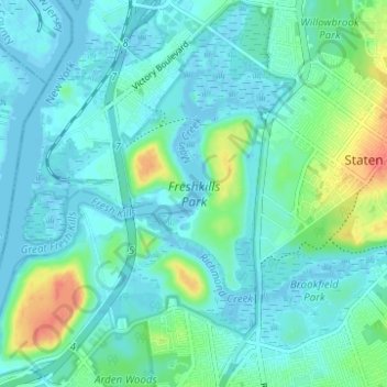
Nom : Carte topographique Freshkills Park, altitude, relief.
Altitude moyenne : 11 m
Altitude minimum : -4 m
Altitude maximum : 53 m
Faire un don
Équipez-vous pour votre prochaine aventure :
En tant que Partenaire Amazon, ce site perçoit une commission sur les achats éligibles sans surcoût pour vous.
Autres cartes topographiques
Cliquez sur une carte pour visualiser sa topographie, son altitude et son relief.
Washington Heights
United States > New York > New York
Because of their abrupt, hilly topography, pedestrian navigation in Upper Manhattan is facilitated by many step streets. The longest of these in Washington Heights, at approximately 130 stairs and with an elevation gain of approximately 65 feet, connects Fort Washington Avenue and Overlook Terrace at 187th…
Altitude moyenne : 25 m
Faire un don
Équipez-vous pour votre prochaine aventure :
En tant que Partenaire Amazon, ce site perçoit une commission sur les achats éligibles sans surcoût pour vous.
Manhattan Island
United States > New York > New York
Marble Hill is one example of how Manhattan's land has been considerably altered by human intervention. The borough has seen substantial land reclamation along its waterfronts since Dutch colonial times, and much of the natural variation in its topography has been evened out.
Altitude moyenne : 17 m
Faire un don
Équipez-vous pour votre prochaine aventure :
En tant que Partenaire Amazon, ce site perçoit une commission sur les achats éligibles sans surcoût pour vous.