
Faire un don
Équipez-vous pour votre prochaine aventure :
En tant que Partenaire Amazon, ce site perçoit une commission sur les achats éligibles sans surcoût pour vous.
Carte topographique Weiherhof
Cliquez sur la carte pour afficher l’altitude.
Faire un don
Équipez-vous pour votre prochaine aventure :
En tant que Partenaire Amazon, ce site perçoit une commission sur les achats éligibles sans surcoût pour vous.
Weiherhof
Das Dorf liegt am Banderbach, einem linken Zufluss der Bibert, am Cadolzburger Höhenzug. Im Westen grenzt der Zirndorfer Stadtwald an, im Norden und Osten der Fürther Stadtwald. Gemeindeverbindungsstraßen führen nach Oberfürberg (1 km nördlich), nach Zirndorf (2,8 km südöstlich), zur Kreisstraße FÜ 19 (1 km südwestlich) und nach Banderbach ebenfalls zur FÜ 19 (0,6 km südlich).
Faire un don
Équipez-vous pour votre prochaine aventure :
En tant que Partenaire Amazon, ce site perçoit une commission sur les achats éligibles sans surcoût pour vous.
À propos de cette carte
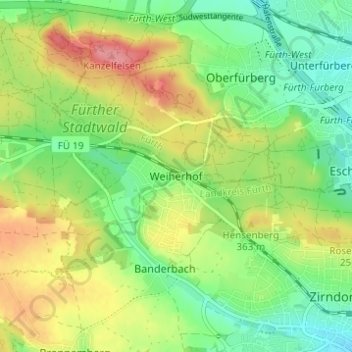
Nom : Carte topographique Weiherhof, altitude, relief.
Altitude moyenne : 339 m
Altitude minimum : 302 m
Altitude maximum : 390 m
Faire un don
Équipez-vous pour votre prochaine aventure :
En tant que Partenaire Amazon, ce site perçoit une commission sur les achats éligibles sans surcoût pour vous.
Autres cartes topographiques
Cliquez sur une carte pour visualiser sa topographie, son altitude et son relief.