
Faire un don
Équipez-vous pour votre prochaine aventure :
En tant que Partenaire Amazon, ce site perçoit une commission sur les achats éligibles sans surcoût pour vous.
Carte topographique Bloomfield Hills
Cliquez sur la carte pour afficher l’altitude.
Faire un don
Équipez-vous pour votre prochaine aventure :
En tant que Partenaire Amazon, ce site perçoit une commission sur les achats éligibles sans surcoût pour vous.
À propos de cette carte
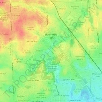
Nom : Carte topographique Bloomfield Hills, altitude, relief.
Altitude moyenne : 261 m
Altitude minimum : 230 m
Altitude maximum : 292 m
Faire un don
Équipez-vous pour votre prochaine aventure :
En tant que Partenaire Amazon, ce site perçoit une commission sur les achats éligibles sans surcoût pour vous.
Autres cartes topographiques
Cliquez sur une carte pour visualiser sa topographie, son altitude et son relief.
Faire un don
Équipez-vous pour votre prochaine aventure :
En tant que Partenaire Amazon, ce site perçoit une commission sur les achats éligibles sans surcoût pour vous.
Jossman Acres
United States > Michigan > Oakland County > Springfield Charter Township
Altitude moyenne : 324 m
Faire un don
Équipez-vous pour votre prochaine aventure :
En tant que Partenaire Amazon, ce site perçoit une commission sur les achats éligibles sans surcoût pour vous.
Carpenter Lake Nature Preserve
United States > Michigan > Oakland County > Southfield
Altitude moyenne : 207 m
Dollar Lake
United States > Michigan > Oakland County > Independence Charter Township
Altitude moyenne : 306 m
Cranberry Lake
United States > Michigan > Oakland County > White Lake Charter Township
Altitude moyenne : 295 m
Faire un don
Équipez-vous pour votre prochaine aventure :
En tant que Partenaire Amazon, ce site perçoit une commission sur les achats éligibles sans surcoût pour vous.
Oxbow
United States > Michigan > Oakland County > White Lake Charter Township
Altitude moyenne : 293 m
Faire un don
Équipez-vous pour votre prochaine aventure :
En tant que Partenaire Amazon, ce site perçoit une commission sur les achats éligibles sans surcoût pour vous.
North Farmington
United States > Michigan > Oakland County > Farmington Hills
Altitude moyenne : 277 m
Union Lake
United States > Michigan > Oakland County > White Lake Charter Township
Altitude moyenne : 290 m
Huron Heights
United States > Michigan > Oakland County > Waterford Charter Township
Altitude moyenne : 292 m
Davisburg
United States > Michigan > Oakland County > Springfield Charter Township
Altitude moyenne : 309 m
Faire un don
Équipez-vous pour votre prochaine aventure :
En tant que Partenaire Amazon, ce site perçoit une commission sur les achats éligibles sans surcoût pour vous.
Rochester Hills
United States > Michigan > Oakland County > Rochester Hills
Rochester Hills is bordered to the north by Oakland Charter Township along Dutton Road, to the south by the city of Troy along South Boulevard, to the east by Shelby Township in Macomb County along Dequindre Road, and to the west by the city of Auburn Hills along part of Adams Road. Rochester Hills is also…
Altitude moyenne : 246 m