
Faire un don
Équipez-vous pour votre prochaine aventure :
En tant que Partenaire Amazon, ce site perçoit une commission sur les achats éligibles sans surcoût pour vous.
Carte topographique Gleed
Cliquez sur la carte pour afficher l’altitude.
Faire un don
Équipez-vous pour votre prochaine aventure :
En tant que Partenaire Amazon, ce site perçoit une commission sur les achats éligibles sans surcoût pour vous.
À propos de cette carte
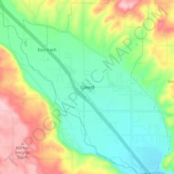
Nom : Carte topographique Gleed, altitude, relief.
Lieu : Gleed, Yakima County, Washington, United States (46.63177 -120.63188 46.68460 -120.57637)
Altitude moyenne : 424 m
Altitude minimum : 354 m
Altitude maximum : 545 m
Faire un don
Équipez-vous pour votre prochaine aventure :
En tant que Partenaire Amazon, ce site perçoit une commission sur les achats éligibles sans surcoût pour vous.
Autres cartes topographiques
Cliquez sur une carte pour visualiser sa topographie, son altitude et son relief.
Mount Adams
United States > Washington > Yakima County
Adams is one of the long-lived volcanoes in the Cascade Range, with minor activity beginning 900,000 years ago and major cone building activity beginning 520,000 years ago. The whole mountain has been completely eroded by glaciers to an elevation of 8,200 feet (2,500 m) twice during its lifetime. The current…
Altitude moyenne : 3 235 m
Faire un don
Équipez-vous pour votre prochaine aventure :
En tant que Partenaire Amazon, ce site perçoit une commission sur les achats éligibles sans surcoût pour vous.
Mount Adams
United States > Washington > Yakima County
The mountain is home to diverse ecological zones, ranging from dense lower-elevation forests dominated by Douglas fir and western hemlock on its western slopes to drier ponderosa pine forests on its eastern slopes. These ecosystems support a rich array of flora and fauna, including large mammals like Roosevelt…
Altitude moyenne : 3 235 m
Faire un don
Équipez-vous pour votre prochaine aventure :
En tant que Partenaire Amazon, ce site perçoit une commission sur les achats éligibles sans surcoût pour vous.
Mount Adams
United States > Washington > Yakima County
Adams is one of the long-lived volcanoes in the Cascade Range, with minor activity beginning 900,000 years ago and major cone building activity beginning 520,000 years ago. The whole mountain has been completely eroded by glaciers to an elevation of 8,200 feet (2,500 m) twice during its lifetime. The current…
Altitude moyenne : 3 235 m
Faire un don
Équipez-vous pour votre prochaine aventure :
En tant que Partenaire Amazon, ce site perçoit une commission sur les achats éligibles sans surcoût pour vous.