
Faire un don
Équipez-vous pour votre prochaine aventure :
En tant que Partenaire Amazon, ce site perçoit une commission sur les achats éligibles sans surcoût pour vous.
Carte topographique Shillong
Cliquez sur la carte pour afficher l’altitude.
Faire un don
Équipez-vous pour votre prochaine aventure :
En tant que Partenaire Amazon, ce site perçoit une commission sur les achats éligibles sans surcoût pour vous.
Shillong
HQ Eastern Air Command (HQ, EAC) was shifted to Shillong on 10 Jun 63 from Kolkata and housed in the old buildings located at Nonglyer village at Upper Shillong, some 10 km from (Lower) Shillong, but at a greater altitude of around 6,000 feet AMSL. Initially a British military base, it was taken over by No. 58 Gorkha Regiment of the Indian Army post Independence in 1947. The Regiment was redeployed after the Sino-Indian War of 1962, making way for the IAF to step in. Only helicopters can operate from HQ, EAC, using a 12.7 hectare (31.3 acre) helipad.
Faire un don
Équipez-vous pour votre prochaine aventure :
En tant que Partenaire Amazon, ce site perçoit une commission sur les achats éligibles sans surcoût pour vous.
À propos de cette carte
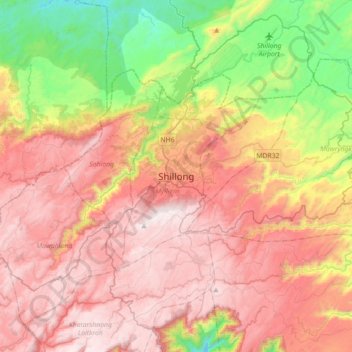
Nom : Carte topographique Shillong, altitude, relief.
Lieu : Shillong, Mylliem, East Khasi Hills, Meghalaya, 793001, India (25.41599 91.72279 25.73599 92.04279)
Altitude moyenne : 1 351 m
Altitude minimum : 659 m
Altitude maximum : 1 958 m
Faire un don
Équipez-vous pour votre prochaine aventure :
En tant que Partenaire Amazon, ce site perçoit une commission sur les achats éligibles sans surcoût pour vous.