
Carte topographique Dunholme
Cliquez sur la carte pour afficher l’altitude.
À propos de cette carte
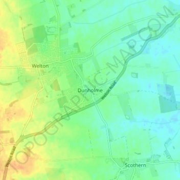
Nom : Carte topographique Dunholme, altitude, relief.
Altitude moyenne : 19 m
Altitude minimum : 7 m
Altitude maximum : 37 m
Autres cartes topographiques
Cliquez sur une carte pour visualiser sa topographie, son altitude et son relief.
Welton CP
United Kingdom > England > Lincolnshire > West Lindsey
The parish stretches from the ancient Ermine Street (A15) in the west, following a north-easterly shape to the Barlings Eau at its eastern end, of which the Welton Beck is a tributary, and is an example of a strip parish. Due to the low, flat topography of Lincolnshire, land had to be drained for agriculture…
Altitude moyenne : 27 m
North Willingham CP
United Kingdom > England > Lincolnshire > West Lindsey > North Willingham CP
Altitude moyenne : 82 m
Corringham CP
United Kingdom > England > Lincolnshire > West Lindsey > Corringham CP
Altitude moyenne : 21 m
Rase Park
United Kingdom > England > Lincolnshire > West Lindsey > Market Rasen
Altitude moyenne : 28 m
Holton cum Beckering CP
United Kingdom > England > Lincolnshire > West Lindsey
Altitude moyenne : 27 m