
Carte topographique Town of Danby
Carte interactive
Cliquez sur la carte pour afficher l’altitude.
À propos de cette carte
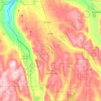
Nom : Carte topographique Town of Danby, altitude, relief.
Lieu : Town of Danby, Tompkins County, New York, United States (42.26275 -76.53851 42.39654 -76.39437)
Altitude moyenne : 404 m
Altitude minimum : 134 m
Altitude maximum : 586 m
Elevations range from approximately 450 feet above sea level where Cayuga Inlet crosses the northern town line, to about 1230 feet at Town Hall in Danby Hamlet, to just over 1800 feet at Dawes Hill in the southwestern part of the town and Roundtop in the southeastern part of the town. The dramatic hill and valley lands of Danby have sometimes been referred to as the 'Danby Highlands'.
Autres cartes topographiques
Cliquez sur une carte pour visualiser sa topographie, son altitude et son relief.
City of Ithaca
United States > New York > Tompkins County
City of Ithaca, Tompkins County, New York, United States
Altitude moyenne : 195 m
Town of Newfield
United States > New York > Tompkins County
Town of Newfield, Tompkins County, New York, 14867, United States
Altitude moyenne : 426 m
Buttermilk Falls State Park
United States > New York > Tompkins County > Ithaca > Town of Danby
Buttermilk Falls State Park, Ithaca, Town of Danby, Tompkins County, New York, United States
Altitude moyenne : 269 m
East Ithaca
United States > New York > Tompkins County > Ithaca > East Ithaca
East Ithaca, Ithaca, Tompkins County, New York, United States
Altitude moyenne : 281 m
Town of Ithaca
United States > New York > Tompkins County
Town of Ithaca, Tompkins County, New York, United States
Altitude moyenne : 288 m
Town of Dryden
United States > New York > Tompkins County
Town of Dryden, Tompkins County, New York, United States
Altitude moyenne : 430 m
Waterburg
United States > New York > Tompkins County > Waterburg
Waterburg, Ulysses Town, Tompkins County, New York, 14886, United States
Altitude moyenne : 318 m