
Carte topographique Town of Cicero
Carte interactive
Cliquez sur la carte pour afficher l’altitude.
À propos de cette carte
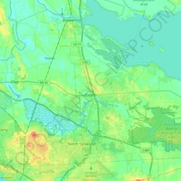
Nom : Carte topographique Town of Cicero, altitude, relief.
Lieu : Town of Cicero, Onondaga County, New York, United States (43.11496 -76.15766 43.24326 -75.95004)
Altitude moyenne : 120 m
Altitude minimum : 108 m
Altitude maximum : 149 m
Autres cartes topographiques
Cliquez sur une carte pour visualiser sa topographie, son altitude et son relief.
City of Syracuse
United States > New York > Onondaga County
City of Syracuse, Onondaga County, New York, United States
Altitude moyenne : 172 m
Hiawatha Lake
United States > New York > Onondaga County > City of Syracuse
Hiawatha Lake, Strathmore, City of Syracuse, Onondaga County, New York, United States
Altitude moyenne : 151 m
Town of Manlius
United States > New York > Onondaga County
Town of Manlius, Onondaga County, New York, United States
Altitude moyenne : 179 m
Town of Clay
United States > New York > Onondaga County
Town of Clay, Onondaga County, New York, United States
Altitude moyenne : 120 m
Camillus
United States > New York > Onondaga County > Camillus
Camillus, Onondaga County, New York, United States
Altitude moyenne : 177 m
Pompey
United States > New York > Onondaga County > Town of Pompey > Pompey
Pompey, Town of Pompey, Onondaga County, New York, 13138, United States
Altitude moyenne : 450 m
Apulia
United States > New York > Onondaga County > Town of Fabius > Apulia
Apulia, Town of Fabius, Onondaga County, New York, 13020, United States
Altitude moyenne : 409 m