
Carte topographique Tibet
Carte interactive
Cliquez sur la carte pour afficher l’altitude.
À propos de cette carte
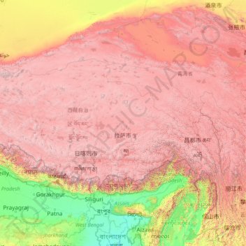
Nom : Carte topographique Tibet, altitude, relief.
Lieu : Tibet, China (27.21205 78.39232 36.48407 99.11555)
Altitude moyenne : 3 040 m
Altitude minimum : -1 m
Altitude maximum : 8 096 m
Durch den Aufbau der medizinischen Versorgung erhöhte sich die Lebenserwartung in Tibet von 35 Jahren im Jahr 1959 auf 67 Jahre im Jahr 2008 und 68,2 Jahre im Jahr 2013. Die um acht Jahre niedrigere Lebenserwartung in Tibet als im übrigen China wird teilweise auf die schwierigen Lebensumstände in über 4000 m Höhe zurückgeführt. Es ist das offizielle Ziel der chinesischen Regierung, die Lebenserwartung bis zum Jahr 2020 auf 70 Jahre zu erhöhen.
Autres cartes topographiques
Cliquez sur une carte pour visualiser sa topographie, son altitude et son relief.
四姑娘山海子沟景区
China > Sichuan > 小金县 བཙན་ལྷ་རྫོང་།
四姑娘山海子沟景区, 小金县 བཙན་ལྷ་རྫོང་།, 阿坝藏族羌族自治州 རྔ་བ་བོད་རིགས་ཆ་བ༹ང་རིགས་རང་སྐྱོང་ཁུལ་, Sichuan, 624200, China
Altitude moyenne : 4 270 m
班戈县 དཔལ་མགོན་རྫོང།
班戈县 དཔལ་མགོན་རྫོང།, Nagqu, Tibet, 852500, China
Altitude moyenne : 4 877 m
帕里镇 ཕག་ར
China > Tibet > 亚东县 གྲོ་མོ་རྫོང།
帕里镇 ཕག་ར, 亚东县 གྲོ་མོ་རྫོང།, Shigatse, Tibet, China
Altitude moyenne : 4 478 m
巴日嘎斯台乡
巴日嘎斯台乡, 科尔沁右翼前旗 ᠬᠣᠷᠴᠢᠨ ᠪᠠᠷᠠᠭᠤᠨ ᠭᠠᠷᠤᠨ ᠡᠮᠦᠨᠡᠳᠦ ᠬᠣᠰᠢᠭᠤ, Hinggan, Innere Mongolei, China
Altitude moyenne : 451 m
锡林郭勒盟 ᠰᠢᠯᠢ ᠶᠢᠨ ᠭᠣᠣᠯ ᠠᠶᠢᠮᠠᠭ
锡林郭勒盟 ᠰᠢᠯᠢ ᠶᠢᠨ ᠭᠣᠣᠯ ᠠᠶᠢᠮᠠᠭ, Innere Mongolei, 692485, China
Altitude moyenne : 1 058 m
Macao
China > Macau > 風順堂區 São Lourenço
Macao, 風順堂區 São Lourenço, Concelho de Macau, Macau, 519020, China
Altitude moyenne : 17 m
扯旗山 Victoria Peak
China > Hongkong > Hong Kong Island
扯旗山 Victoria Peak, Hong Kong Island, Hongkong, China
Altitude moyenne : 209 m
Victoria Peak Lookout (over the Victoria Harbour)
China > Hongkong > Hong Kong Island
Victoria Peak Lookout (over the Victoria Harbour), 盧吉道 Lugard Road, 太平山 Victoria Peak, 山頂 The Peak, 中西區 Central and Western District, Hong Kong Island, Hongkong, China
Altitude moyenne : 191 m