
Carte topographique Santry
Cliquez sur la carte pour afficher l’altitude.
À propos de cette carte
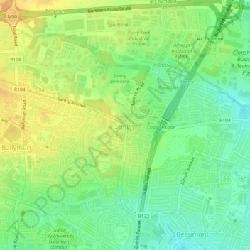
Nom : Carte topographique Santry, altitude, relief.
Altitude moyenne : 54 m
Altitude minimum : 38 m
Altitude maximum : 68 m
Autres cartes topographiques
Cliquez sur une carte pour visualiser sa topographie, son altitude et son relief.
Dublin Castle
Ireland > County Dublin > Dublin
The Poddle was diverted into the city through archways where the walls adjoined the castle, artificially flooding the moat of the fortress's city elevations. One of these archways and part of the wall survive buried underneath the 18th-century buildings, and are open for public viewing.
Altitude moyenne : 16 m