
Carte topographique Gangotri National Park
Carte interactive
Cliquez sur la carte pour afficher l’altitude.
À propos de cette carte
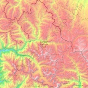
Nom : Carte topographique Gangotri National Park, altitude, relief.
Altitude moyenne : 5 008 m
Altitude minimum : 2 497 m
Altitude maximum : 7 135 m
The park harbors Western Himalayan subalpine conifer forests at lower elevations and Western Himalayan alpine shrub and meadows at higher elevations. Vegetation consist of chirpine deodar, fir, spruce, oak and rhododendrons.
Autres cartes topographiques
Cliquez sur une carte pour visualiser sa topographie, son altitude et son relief.
Didsari
India > Uttarakhand > Bhatwari
Didsari, Bhatwari, Uttarkashi district, Uttarakhand, India
Altitude moyenne : 1 801 m
Dayara
India > Uttarakhand > Bhatwari
Dayara, Bhatwari, Uttarkashi district, Uttarakhand, India
Altitude moyenne : 3 409 m
Uttarkashi
India > Uttarakhand > Bhatwari
Uttarkashi, Bhatwari, Uttarkashi district, Uttarakhand, 249193, India
Altitude moyenne : 1 619 m
Shivling
India > Uttarakhand > Bhatwari
Shivling, Bhatwari, Uttarkashi district, Uttarakhand, India
Altitude moyenne : 5 440 m
Gangotri
India > Uttarakhand > Bhatwari
Gangotri, Bhatwari, Uttarkashi District, Uttarakhand, India
Altitude moyenne : 4 139 m
Barsu
India > Uttarakhand > Bhatwari > Barsu
Barsu, Bhatwari, Uttarkashi, Uttarakhand, India
Altitude moyenne : 2 322 m
Raithal
India > Uttarakhand > Bhatwari > Raithal
Raithal, Bhatwari, Uttarkashi, Uttarakhand, India
Altitude moyenne : 2 122 m
Bhaironghati
India > Uttarakhand > Bhatwari > Lanka > Bhaironghati
Bhaironghati, Lanka, Bhatwari, Uttarkashi, Uttarakhand, India
Altitude moyenne : 3 227 m
Bhatwari
India > Uttarakhand > Bhatwari
Bhatwari, Uttarkashi district, Uttarakhand, India
Altitude moyenne : 4 572 m
Gangotri Glacier
India > Uttarakhand > Bhatwari
Gangotri Glacier, Bhatwari, Uttarkashi, Uttarakhand, India
Altitude moyenne : 5 259 m