
Carte topographique Aberlour
Cliquez sur la carte pour afficher l’altitude.
Aberlour
According to the 1846 A Topographical Dictionary of Scotland, "This parish, formerly called Skirdustan, signifying, in the Gaelic tongue, 'the division of Dustan', its tutelary saint, derived its present name from its situation at the mouth of a noisy burn, which discharges itself into the river Spey."
À propos de cette carte
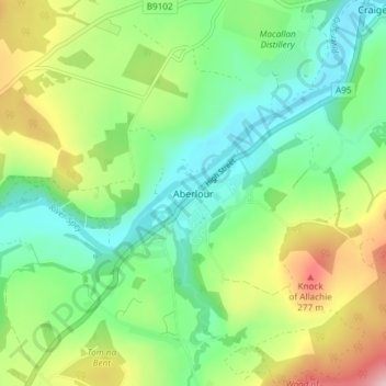
Nom : Carte topographique Aberlour, altitude, relief.
Lieu : Aberlour, Moray, Scotland, AB38 9PX, United Kingdom (57.45079 -3.24554 57.49079 -3.20554)
Altitude moyenne : 160 m
Altitude minimum : 75 m
Altitude maximum : 326 m
Autres cartes topographiques
Cliquez sur une carte pour visualiser sa topographie, son altitude et son relief.
Fochabers
United Kingdom > Scotland > Moray
The present village owes its existence to Alexander Gordon, 4th Duke of Gordon (1743–1827). During the late eighteenth century, during the Scottish Enlightenment, it was fashionable for landowners to found new towns and villages; these can be recognised all over Scotland, because unlike their predecessors…
Altitude moyenne : 59 m