
Carte topographique Abbottabad
Carte interactive
Cliquez sur la carte pour afficher l’altitude.
À propos de cette carte
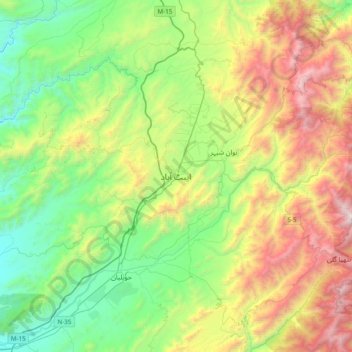
Nom : Carte topographique Abbottabad, altitude, relief.
Altitude moyenne : 1 363 m
Altitude minimum : 554 m
Altitude maximum : 2 924 m
Abbottabad (/ˈæbətəbɑːd/; Urdu, Hindko: ایبٹ آباد, romanized: aibṭabād, pronounced [ɛːbʈəˈbaːd̪]) is the capital city of Abbottabad District in the Hazara region of eastern Khyber Pakhtunkhwa, Pakistan. It is the 40th largest city in Pakistan and fourth largest in the province of Khyber Pakhtunkhwa by population. It is about 120 km (75 mi) north of Islamabad-Rawalpindi and 150 km (95 mi) east of Peshawar, at an elevation of 1,256 m (4,121 ft). Kashmir lies a short distance to the east.
Autres cartes topographiques
Cliquez sur une carte pour visualiser sa topographie, son altitude et son relief.
Changla Gali
Pakistan > Khyber Pakhtunkhwa > Abbottābād District
Changla Gali, Abbottabad Tehsil, Abbottabad District, Hazara Division, Khyber Pakhtunkhwa, Pakistan
Altitude moyenne : 2 143 m
Sherwan
Pakistan > Khyber Pakhtunkhwa > Abbottābād District
Sherwan, Lower Tanawal Tehsil, Abbottabad District, Hazara Division, Khyber Pakhtunkhwa, Pakistan
Altitude moyenne : 1 026 m
Haripur
Pakistan > Khyber Pakhtunkhwa > Abbottābād District
Haripur, Abbottābād District, Khyber Pakhtunkhwa, 22620, Pakistan
Altitude moyenne : 691 m
Nathia Gali
Pakistan > Khyber Pakhtunkhwa > Abbottābād District
Nathia Gali, Abbottabad Tehsil, Abbottabad District, Hazara Division, Khyber Pakhtunkhwa, Pakistan
Altitude moyenne : 2 137 m