
Faire un don
Équipez-vous pour votre prochaine aventure :
En tant que Partenaire Amazon, ce site perçoit une commission sur les achats éligibles sans surcoût pour vous.
Carte topographique Hampton
Cliquez sur la carte pour afficher l’altitude.
Faire un don
Équipez-vous pour votre prochaine aventure :
En tant que Partenaire Amazon, ce site perçoit une commission sur les achats éligibles sans surcoût pour vous.
À propos de cette carte
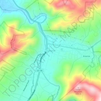
Nom : Carte topographique Hampton, altitude, relief.
Altitude moyenne : 674 m
Altitude minimum : 496 m
Altitude maximum : 1 014 m
Faire un don
Équipez-vous pour votre prochaine aventure :
En tant que Partenaire Amazon, ce site perçoit une commission sur les achats éligibles sans surcoût pour vous.
Autres cartes topographiques
Cliquez sur une carte pour visualiser sa topographie, son altitude et son relief.
Watauga Lake
United States > Tennessee > Carter County
According to the 2004 TVA River and Reservoir Operations Study, Watauga Lake is approximately 16.3 mi (26.2 km) long, with 104.9 mi (168.8 km) of shoreline. At the TVA summertime water level target "full pool", the lake surface covers 6,430 acres (26 km²) and the estimated depth of Watauga Lake is 265 feet…
Altitude moyenne : 755 m
Roan Mountain
United States > Tennessee > Carter County
Roan Mountain is located in northeast Tennessee at 36°11′39″N 82°4′6″W / 36.19417°N 82.06833°W / 36.19417; -82.06833 (36.194219, -82.068417). According to the United States Census Bureau, the CDP has a total area of 6.6 square miles (17.2 km2), all land. The elevation of Roan Mountain near…
Altitude moyenne : 926 m
Roan Mountain State Park
United States > Tennessee > Carter County > Roan Mountain
Roan Mountain State Park hosts a variety of outdoor activities including hiking, mountain biking, camping, cross-country skiing (during snowy, winter months), fishing, and swimming. A heated swimming pool is open from Memorial Day to mid-August. At an elevation of 2,972 feet (906 m), the outdoor swimming pool…
Altitude moyenne : 988 m
Faire un don
Équipez-vous pour votre prochaine aventure :
En tant que Partenaire Amazon, ce site perçoit une commission sur les achats éligibles sans surcoût pour vous.
Elizabethton
United States > Tennessee > Carter County
The elevation at Elizabethton Municipal Airport is 1,593 feet (486 m) ASL (the highest point of elevation in Carter County is at Roan Mountain with an elevation of 6,285 feet (1,916 m) ASL), and the airport is located on the eastern side of the city along State Highway 91 Stoney Creek Exit. Elizabethton is…
Altitude moyenne : 567 m
Roan Mountain
United States > Tennessee > Carter County
Roan Mountain is located in northeast Tennessee at 36°11′39″N 82°4′6″W / 36.19417°N 82.06833°W / 36.19417; -82.06833 (36.194219, -82.068417). According to the United States Census Bureau, the CDP has a total area of 6.6 square miles (17.2 km2), all land. The elevation of Roan Mountain near…
Altitude moyenne : 926 m
Elizabethton
United States > Tennessee > Carter County
The elevation at Elizabethton Municipal Airport is 1,593 feet (486 m) ASL (the highest point of elevation in Carter County is at Roan Mountain with an elevation of 6,285 feet (1,916 m) ASL), and the airport is located on the eastern side of the city along State Highway 91 Stoney Creek Exit. Elizabethton is…
Altitude moyenne : 567 m
Faire un don
Équipez-vous pour votre prochaine aventure :
En tant que Partenaire Amazon, ce site perçoit une commission sur les achats éligibles sans surcoût pour vous.