
Faire un don
Équipez-vous pour votre prochaine aventure :
En tant que Partenaire Amazon, ce site perçoit une commission sur les achats éligibles sans surcoût pour vous.
Carte topographique North Union Township
Cliquez sur la carte pour afficher l’altitude.
Faire un don
Équipez-vous pour votre prochaine aventure :
En tant que Partenaire Amazon, ce site perçoit une commission sur les achats éligibles sans surcoût pour vous.
North Union Township
The eastern half of Union Township occupies the hilltops and western slope of Chestnut Ridge, with the highest elevation of 2,670 feet (810 m) located near the southeast corner of the township, just north of the Summit Hotel. The lowest point in the township is 910 feet (280 m) above sea level, along Redstone Creek where it exits the township from its northwest corner.
Faire un don
Équipez-vous pour votre prochaine aventure :
En tant que Partenaire Amazon, ce site perçoit une commission sur les achats éligibles sans surcoût pour vous.
À propos de cette carte
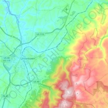
Nom : Carte topographique North Union Township, altitude, relief.
Altitude moyenne : 447 m
Altitude minimum : 275 m
Altitude maximum : 815 m
Faire un don
Équipez-vous pour votre prochaine aventure :
En tant que Partenaire Amazon, ce site perçoit une commission sur les achats éligibles sans surcoût pour vous.