
Faire un don
Équipez-vous pour votre prochaine aventure :
En tant que Partenaire Amazon, ce site perçoit une commission sur les achats éligibles sans surcoût pour vous.
Carte topographique Atigun Pass
Cliquez sur la carte pour afficher l’altitude.
Faire un don
Équipez-vous pour votre prochaine aventure :
En tant que Partenaire Amazon, ce site perçoit une commission sur les achats éligibles sans surcoût pour vous.
Atigun Pass
Atigun Pass (/ˈætɪɡən/ AT-i-gən), elevation 4,739 feet (1,444 m), is a high mountain pass across the Brooks Range in Alaska, located at the head of the Dietrich River. It is where the Dalton Highway crosses the Continental Divide (at mile marker 244), and is the highest pass in Alaska that is maintained throughout the year. Atigun is the only pass in the Brooks Range that is crossed by a road. The pass has been responsible for taking many drivers off the road and is also home to avalanches during the winter.
Faire un don
Équipez-vous pour votre prochaine aventure :
En tant que Partenaire Amazon, ce site perçoit une commission sur les achats éligibles sans surcoût pour vous.
À propos de cette carte
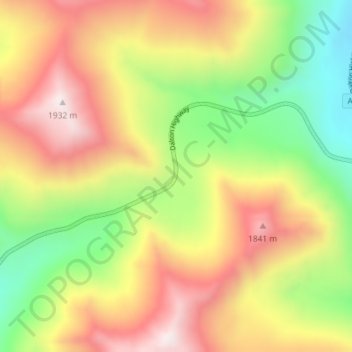
Nom : Carte topographique Atigun Pass, altitude, relief.
Lieu : Atigun Pass, North Slope Borough, Alaska, United States (68.13006 -149.48040 68.13016 -149.48030)
Altitude moyenne : 1 530 m
Altitude minimum : 1 149 m
Altitude maximum : 1 936 m
Faire un don
Équipez-vous pour votre prochaine aventure :
En tant que Partenaire Amazon, ce site perçoit une commission sur les achats éligibles sans surcoût pour vous.
Autres cartes topographiques
Cliquez sur une carte pour visualiser sa topographie, son altitude et son relief.
Toolik Lake
United States > Alaska > North Slope Borough
Tussock tundra dominates the terrain surrounding the lake. Other plant communities in the area include wet sedge tundra, as well drier heath tundra found at higher elevations. Low growing shrubs are abundant, including birches and willows. Trees are not present. Since surveys began, there has been a 19 percent…
Altitude moyenne : 731 m
Faire un don
Équipez-vous pour votre prochaine aventure :
En tant que Partenaire Amazon, ce site perçoit une commission sur les achats éligibles sans surcoût pour vous.
Utqiaġvik
United States > Alaska > North Slope Borough
Despite the extreme northern location, temperatures at Utqiagvik are moderated by the surrounding topography. The Arctic Ocean is on three sides, and flat tundra stretches some 200 mi (320 km) to the south. No wind barriers or protected valleys exist where dense cold air can settle or form temperature…
Altitude moyenne : 4 m
Toolik Lake
United States > Alaska > North Slope Borough
Tussock tundra dominates the terrain surrounding the lake. Other plant communities in the area include wet sedge tundra, as well drier heath tundra found at higher elevations. Low growing shrubs are abundant, including birches and willows. Trees are not present. Since surveys began, there has been a 19 percent…
Altitude moyenne : 731 m