
Faire un don
Équipez-vous pour votre prochaine aventure :
En tant que Partenaire Amazon, ce site perçoit une commission sur les achats éligibles sans surcoût pour vous.
Carte topographique Brentwood
Cliquez sur la carte pour afficher l’altitude.
Faire un don
Équipez-vous pour votre prochaine aventure :
En tant que Partenaire Amazon, ce site perçoit une commission sur les achats éligibles sans surcoût pour vous.
À propos de cette carte
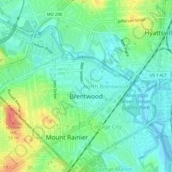
Nom : Carte topographique Brentwood, altitude, relief.
Altitude moyenne : 17 m
Altitude minimum : -2 m
Altitude maximum : 54 m
Faire un don
Équipez-vous pour votre prochaine aventure :
En tant que Partenaire Amazon, ce site perçoit une commission sur les achats éligibles sans surcoût pour vous.
Autres cartes topographiques
Cliquez sur une carte pour visualiser sa topographie, son altitude et son relief.
Wildercroft
United States > Maryland > Prince George's County > East Riverdale
Altitude moyenne : 39 m
Faire un don
Équipez-vous pour votre prochaine aventure :
En tant que Partenaire Amazon, ce site perçoit une commission sur les achats éligibles sans surcoût pour vous.
White Hall Terrace
United States > Maryland > Prince George's County > Accokeek
Altitude moyenne : 59 m
Upper Marlboro
United States > Maryland > Prince George's County > Upper Marlboro > Upper Marlboro
Altitude moyenne : 27 m
Faire un don
Équipez-vous pour votre prochaine aventure :
En tant que Partenaire Amazon, ce site perçoit une commission sur les achats éligibles sans surcoût pour vous.
Lake Artemesia
United States > Maryland > Prince George's County > College Park
Altitude moyenne : 26 m
Faire un don
Équipez-vous pour votre prochaine aventure :
En tant que Partenaire Amazon, ce site perçoit une commission sur les achats éligibles sans surcoût pour vous.
Andrews Manor
United States > Maryland > Prince George's County > Camp Springs
Altitude moyenne : 79 m
Hyattsville
United States > Maryland > Prince George's County
Downtown Hyattsville underwent revitalization in the early 2000s with the development of Arts District Hyattsville, part of the Gateway Arts District, a private project which includes townhomes, live-work units, and retail space. The master developer of the 25-acre neighborhood was Bethesda-based EYA, and was…
Altitude moyenne : 61 m
Faire un don
Équipez-vous pour votre prochaine aventure :
En tant que Partenaire Amazon, ce site perçoit une commission sur les achats éligibles sans surcoût pour vous.
Faire un don
Équipez-vous pour votre prochaine aventure :
En tant que Partenaire Amazon, ce site perçoit une commission sur les achats éligibles sans surcoût pour vous.
District Heights
United States > Maryland > Prince George's County > District Heights > District Heights
Altitude moyenne : 73 m
Faire un don
Équipez-vous pour votre prochaine aventure :
En tant que Partenaire Amazon, ce site perçoit une commission sur les achats éligibles sans surcoût pour vous.
Piscataway
United States > Maryland > Prince George's County > Fort Washington
Altitude moyenne : 36 m
Greater Capitol Heights
United States > Maryland > Prince George's County > Maryland Park > Greater Capitol Heights
Altitude moyenne : 59 m
Seabrook Acres
United States > Maryland > Prince George's County > Seabrook > Seabrook Acres
Altitude moyenne : 50 m
Faire un don
Équipez-vous pour votre prochaine aventure :
En tant que Partenaire Amazon, ce site perçoit une commission sur les achats éligibles sans surcoût pour vous.
Mount Rainier Community Food Forest
United States > Maryland > Prince George's County > Mount Rainier
Altitude moyenne : 23 m