
Carte topographique Aït Ghmat
Carte interactive
Cliquez sur la carte pour afficher l’altitude.
À propos de cette carte
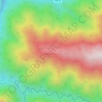
Nom : Carte topographique Aït Ghmat, altitude, relief.
Lieu : Aït Ghmat, Souhane, Daïra Larbâa, Blida, Algérie (36.50405 3.20150 36.50415 3.20160)
Altitude moyenne : 543 m
Altitude minimum : 217 m
Altitude maximum : 919 m
Autres cartes topographiques
Cliquez sur une carte pour visualiser sa topographie, son altitude et son relief.
Sahraoui
Algérie > Blida > Daïra Larbâa > Larbaa
Sahraoui, Larbaa, Daïra Larbâa, Blida, 09300, Algérie
Altitude moyenne : 90 m
Belaouadi
Algérie > Blida > Daïra Larbâa > Larbaa
Belaouadi, Larbaa, Daïra Larbâa, Blida, 16189, Algérie
Altitude moyenne : 64 m
Larbaa
Algérie > Blida > Daïra Larbâa
Larbaa, Daïra Larbâa, Blida, 09300, Algérie
Altitude moyenne : 200 m