
Carte topographique Bonnyrigg
Carte interactive
Cliquez sur la carte pour afficher l’altitude.
À propos de cette carte
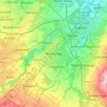
Nom : Carte topographique Bonnyrigg, altitude, relief.
Lieu : Bonnyrigg, Midlothian, Scotland, EH19 2DA, United Kingdom (55.83512 -3.14591 55.91512 -3.06591)
Altitude moyenne : 114 m
Altitude minimum : 25 m
Altitude maximum : 257 m
Autres cartes topographiques
Cliquez sur une carte pour visualiser sa topographie, son altitude et son relief.
Castlelaw
United Kingdom > Scotland > Midlothian
Castlelaw, Midlothian, Scotland, EH26 0PB, United Kingdom
Altitude moyenne : 271 m
Dryden Farm
United Kingdom > Scotland > Midlothian > Loanhead
Dryden Farm, Loanhead, Midlothian, Scotland, EH25 9PS, United Kingdom
Altitude moyenne : 144 m
Bilston
United Kingdom > Scotland > Midlothian
Bilston, Midlothian, Scotland, EH25 9SH, United Kingdom
Altitude moyenne : 169 m
Loanhead
United Kingdom > Scotland > Midlothian
Loanhead, Midlothian, Scotland, EH20 9RG, United Kingdom
Altitude moyenne : 133 m
Rosewell
United Kingdom > Scotland > Midlothian
Rosewell, Midlothian, Scotland, EH24 9AA, United Kingdom
Altitude moyenne : 152 m