
Carte topographique Elland
Cliquez sur la carte pour afficher l’altitude.
À propos de cette carte
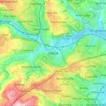
Nom : Carte topographique Elland, altitude, relief.
Altitude moyenne : 163 m
Altitude minimum : 56 m
Altitude maximum : 382 m
Autres cartes topographiques
Cliquez sur une carte pour visualiser sa topographie, son altitude et son relief.
Todmorden
United Kingdom > England > Calderdale > Lydgate
Todmorden Town Hall, which was designed in the Neo-Classical style, dominates the centre of the town. The building straddles the Walsden Water, a tributary of the River Calder, and was situated in both Lancashire and Yorkshire until the administrative county boundary was moved on 1 January 1888. Designed by…
Altitude moyenne : 311 m
Calder & Hebble Navigation Halifax Cut
United Kingdom > England > Calderdale > Skircoat Green
Altitude moyenne : 136 m
Ragby Plantation
United Kingdom > England > Calderdale > Todmorden > Walsden > Bottoms
Altitude moyenne : 293 m
Gaddings Dam
United Kingdom > England > Calderdale > Todmorden > Walsden
Gaddings Dam is a locally owned reservoir near to Todmorden in West Yorkshire, England. The dam was built to power water mills in the Todmorden area, being superseded by steam power and left redundant. It is notable for having a sandy beach at the north-eastern side which attracts people to it during the…
Altitude moyenne : 283 m
Todmorden
United Kingdom > England > Calderdale
Todmorden Town Hall, which was designed in the Neo-Classical style, dominates the centre of the town. The building straddles the Walsden Water, a tributary of the River Calder, and was situated in both Lancashire and Yorkshire until the administrative county boundary was moved on 1 January 1888. Designed by…
Altitude moyenne : 311 m