
Faire un don
Équipez-vous pour votre prochaine aventure :
En tant que Partenaire Amazon, ce site perçoit une commission sur les achats éligibles sans surcoût pour vous.
Carte topographique Watertown
Cliquez sur la carte pour afficher l’altitude.
Faire un don
Équipez-vous pour votre prochaine aventure :
En tant que Partenaire Amazon, ce site perçoit une commission sur les achats éligibles sans surcoût pour vous.
Watertown
Watertown is in southeastern Litchfield County and is bordered to the southeast by the city of Waterbury in New Haven County. Other bordering towns are Middlebury to the south, Woodbury and Bethlehem to the west, Morris to the northwest, and Thomaston to the east. It is in the Eastern Standard time zone. The elevation at the town center is 583 feet (178 m).
Faire un don
Équipez-vous pour votre prochaine aventure :
En tant que Partenaire Amazon, ce site perçoit une commission sur les achats éligibles sans surcoût pour vous.
À propos de cette carte
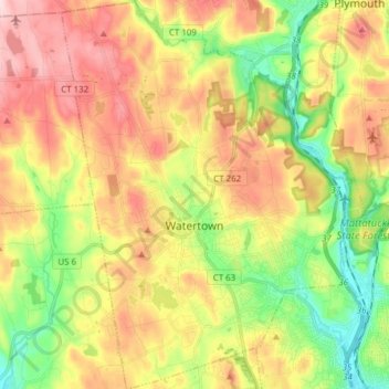
Nom : Carte topographique Watertown, altitude, relief.
Altitude moyenne : 199 m
Altitude minimum : 75 m
Altitude maximum : 336 m
Faire un don
Équipez-vous pour votre prochaine aventure :
En tant que Partenaire Amazon, ce site perçoit une commission sur les achats éligibles sans surcoût pour vous.
Autres cartes topographiques
Cliquez sur une carte pour visualiser sa topographie, son altitude et son relief.
Huntington
United States > Connecticut > Naugatuck Valley Planning Region > Shelton
Altitude moyenne : 111 m
Minortown
United States > Connecticut > Naugatuck Valley Planning Region > Woodbury
Altitude moyenne : 169 m
White Hills
United States > Connecticut > Naugatuck Valley Planning Region > Shelton
Altitude moyenne : 124 m
Faire un don
Équipez-vous pour votre prochaine aventure :
En tant que Partenaire Amazon, ce site perçoit une commission sur les achats éligibles sans surcoût pour vous.
Mad River
United States > Connecticut > Naugatuck Valley Planning Region > Waterbury > Fair Lawn
Altitude moyenne : 134 m
Traditions
United States > Connecticut > Naugatuck Valley Planning Region > Southbury > South Britain
Altitude moyenne : 112 m
Fox Hollow
United States > Connecticut > Naugatuck Valley Planning Region > Cheshire
Altitude moyenne : 64 m
Westview Heights
United States > Connecticut > Naugatuck Valley Planning Region > Middlebury
Altitude moyenne : 159 m
Faire un don
Équipez-vous pour votre prochaine aventure :
En tant que Partenaire Amazon, ce site perçoit une commission sur les achats éligibles sans surcoût pour vous.
Union City
United States > Connecticut > Naugatuck Valley Planning Region > Naugatuck
Altitude moyenne : 124 m
Warsaw Park
United States > Connecticut > Naugatuck Valley Planning Region > Ansonia
Altitude moyenne : 107 m
Bunker Hill
United States > Connecticut > Naugatuck Valley Planning Region > Waterbury
Altitude moyenne : 140 m
Faire un don
Équipez-vous pour votre prochaine aventure :
En tant que Partenaire Amazon, ce site perçoit une commission sur les achats éligibles sans surcoût pour vous.
Cedar Land
United States > Connecticut > Naugatuck Valley Planning Region > Southbury
Altitude moyenne : 103 m
Town Plot Hill
United States > Connecticut > Naugatuck Valley Planning Region > Waterbury
Altitude moyenne : 127 m
Millville
United States > Connecticut > Naugatuck Valley Planning Region > Naugatuck
Altitude moyenne : 132 m
Bunker Hill
United States > Connecticut > Naugatuck Valley Planning Region > Waterbury
Altitude moyenne : 140 m
Faire un don
Équipez-vous pour votre prochaine aventure :
En tant que Partenaire Amazon, ce site perçoit une commission sur les achats éligibles sans surcoût pour vous.
Bunker Hill
United States > Connecticut > Naugatuck Valley Planning Region > Waterbury
Altitude moyenne : 140 m
Minortown
United States > Connecticut > Naugatuck Valley Planning Region > Woodbury
Altitude moyenne : 169 m
Gulls Hollow
United States > Connecticut > Naugatuck Valley Planning Region > Bethlehem
Altitude moyenne : 243 m
Allentown
United States > Connecticut > Naugatuck Valley Planning Region > Plymouth
Altitude moyenne : 244 m
Faire un don
Équipez-vous pour votre prochaine aventure :
En tant que Partenaire Amazon, ce site perçoit une commission sur les achats éligibles sans surcoût pour vous.