Carte topographique Knapton
Cliquez sur la carte pour afficher l’altitude.
Knapton
The present church dates from mainly the 14th century. The tower is set into the north west corner of the building. The porch is on the southern elevation. Atop of the church there is a weathervane designed by J.S. Cotman an artist famed as a member of the Norwich school. Inside there is a 13th-century font on three high steps which has a Purbeck marble bowl and a cover over which dates from 1704. The inscription which is in Greek reads "wash my sins and not my face only" The inscription is a palindrome, reading the same backwards as forwards.. At the back of the church behind the font there are some coffin-lids from the earlier church set into the flags of the floor. The most prominent feature of this church is the roof. The roof was given to the church by a John Smithe in 1504. It is of a double hammerbeam construction and still retains its original colour. The beams and spandrels are richly carved with three tiers of angels which have outspread wings. More angels are carved on the kingposts and on the wall plate. In niches below the wall supports there are figures with scrolls, shields, symbols or playing musical instruments. The church is a Grade I listed building.
À propos de cette carte
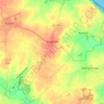
Nom : Carte topographique Knapton, altitude, relief.
Lieu : Knapton, North Norfolk, Norfolk, England, United Kingdom (52.83071 1.39914 52.87126 1.43681)
Altitude moyenne : 29 m
Altitude minimum : 0 m
Altitude maximum : 46 m
Autres cartes topographiques
Cliquez sur une carte pour visualiser sa topographie, son altitude et son relief.