
Faire un don
Équipez-vous pour votre prochaine aventure :
En tant que Partenaire Amazon, ce site perçoit une commission sur les achats éligibles sans surcoût pour vous.
Carte topographique Jefferson Township
Cliquez sur la carte pour afficher l’altitude.
Faire un don
Équipez-vous pour votre prochaine aventure :
En tant que Partenaire Amazon, ce site perçoit une commission sur les achats éligibles sans surcoût pour vous.
Jefferson Township
Blacklick Creek and its associated tributaries of its watershed such as Swisher Creek flow through Jefferson Township. Big Walnut Creek is also to the west of the township while some of its tributaries such as Rocky Fork Creek travel through the western part of Jefferson Township. This has caused the topography in the township to be more varied then some of the surrounding areas from the resulting from these stream corridors, hills, ravines, and slopes much of it associated with the waterways, tributaries, and floodplain that Jefferson Township is in from Rocky Fork, Blacklick, and Swisher Creeks
Faire un don
Équipez-vous pour votre prochaine aventure :
En tant que Partenaire Amazon, ce site perçoit une commission sur les achats éligibles sans surcoût pour vous.
À propos de cette carte
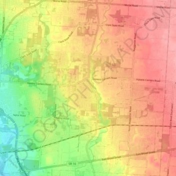
Nom : Carte topographique Jefferson Township, altitude, relief.
Altitude moyenne : 293 m
Altitude minimum : 234 m
Altitude maximum : 334 m
Faire un don
Équipez-vous pour votre prochaine aventure :
En tant que Partenaire Amazon, ce site perçoit une commission sur les achats éligibles sans surcoût pour vous.
Autres cartes topographiques
Cliquez sur une carte pour visualiser sa topographie, son altitude et son relief.
Columbus
United States > Ohio > Franklin County > Columbus
The confluence of the Scioto and Olentangy rivers is just north-west of Downtown Columbus. Several smaller tributaries course through the Columbus metropolitan area, including Alum Creek, Big Walnut Creek, and Darby Creek. Columbus is considered to have relatively flat topography thanks to a large glacier that…
Altitude moyenne : 255 m
Faire un don
Équipez-vous pour votre prochaine aventure :
En tant que Partenaire Amazon, ce site perçoit une commission sur les achats éligibles sans surcoût pour vous.
Faire un don
Équipez-vous pour votre prochaine aventure :
En tant que Partenaire Amazon, ce site perçoit une commission sur les achats éligibles sans surcoût pour vous.
Pickerington Ponds Metro Park
United States > Ohio > Franklin County > Columbus
Altitude moyenne : 241 m
Edward S. Thomas Nature Preserve
United States > Ohio > Franklin County > Columbus
Altitude moyenne : 275 m
Faire un don
Équipez-vous pour votre prochaine aventure :
En tant que Partenaire Amazon, ce site perçoit une commission sur les achats éligibles sans surcoût pour vous.