
Faire un don
Équipez-vous pour votre prochaine aventure :
En tant que Partenaire Amazon, ce site perçoit une commission sur les achats éligibles sans surcoût pour vous.
Carte topographique Picayune
Cliquez sur la carte pour afficher l’altitude.
Faire un don
Équipez-vous pour votre prochaine aventure :
En tant que Partenaire Amazon, ce site perçoit une commission sur les achats éligibles sans surcoût pour vous.
Picayune
Picayune occupies a low, gently undulating landscape in southern Pearl River County, within Mississippi’s Gulf Coastal Plain, where the terrain is marked by faint relief, sandy and clayey soils, and broad, poorly drained lowlands associated with marshy or swampy tracts. The city’s elevation is modest—around 73 ft (22 m) in general references, with the local surface shown here varying roughly from near 7 ft to 125 ft (2 m to 38 m)—and the highest ground tends to form subdued rises and interfluves to the north and east, while lower areas follow the drainage corridors of Mill Creek, East Hobolochitto Creek, Bay Branch, and the nearby Pearl River lowlands. Overall, Picayune’s physical character is that of a humid coastal-plain town: mostly flat to softly rolling, with shallow elevation gradients, stream-cut swales, floodplain margins, and pine-covered sandy uplands creating a landscape where drainage patterns and floodplain topography are more defining than steep slopes or prominent hills.
Faire un don
Équipez-vous pour votre prochaine aventure :
En tant que Partenaire Amazon, ce site perçoit une commission sur les achats éligibles sans surcoût pour vous.
À propos de cette carte
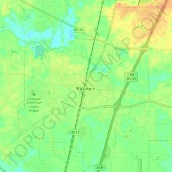
Nom : Carte topographique Picayune, altitude, relief.
Lieu : Picayune, Pearl River County, Mississippi, United States (30.48851 -89.71472 30.56469 -89.64188)
Altitude moyenne : 19 m
Altitude minimum : 3 m
Altitude maximum : 38 m
Faire un don
Équipez-vous pour votre prochaine aventure :
En tant que Partenaire Amazon, ce site perçoit une commission sur les achats éligibles sans surcoût pour vous.
Autres cartes topographiques
Cliquez sur une carte pour visualiser sa topographie, son altitude et son relief.