
Carte topographique Indianapolis
Carte interactive
Cliquez sur la carte pour afficher l’altitude.
À propos de cette carte
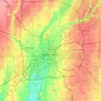
Nom : Carte topographique Indianapolis, altitude, relief.
Lieu : Indianapolis, Marion County, Indiana, United States (39.63216 -86.32812 39.92753 -85.93804)
Altitude moyenne : 241 m
Altitude minimum : 196 m
Altitude maximum : 283 m
Indianapolis is located within a physiographic province known as the Tipton Till Plain, a flat, gently rolling terrain underlain by glacial deposits known as till. The lowest point in the city is about 650 feet (198 m) above mean sea level, with the highest natural elevation at about 900 feet (274 m) above sea level. Few hills or short ridges, known as kames, rise about 100 feet (30 m) to 130 feet (40 m) above the surrounding terrain. The city lies just north of the Indiana Uplands, a region characterized by rolling hills and high limestone content.
Autres cartes topographiques
Cliquez sur une carte pour visualiser sa topographie, son altitude et son relief.
Drexel Gardens
United States > Indiana > Marion County > Indianapolis
Drexel Gardens, Indianapolis, Marion County, Indiana, 46241, United States
Altitude moyenne : 226 m
Wolfington
United States > Indiana > Marion County > Indianapolis
Wolfington, Indianapolis, Marion County, Indiana, 46228, United States
Altitude moyenne : 230 m
Farleys Addition
United States > Indiana > Marion County > Indianapolis
Farleys Addition, Indianapolis, Marion County, Indiana, 36224, United States
Altitude moyenne : 235 m
Fox Hollow
United States > Indiana > Marion County > Indianapolis > Fox Hollow
Fox Hollow, Indianapolis, Marion County, Indiana, 46239, United States
Altitude moyenne : 252 m
Crows Nest
United States > Indiana > Marion County
Crows Nest, Marion County, Indiana, United States
Altitude moyenne : 229 m