
Carte topographique Beilstein
Carte interactive
Cliquez sur la carte pour afficher l’altitude.
À propos de cette carte
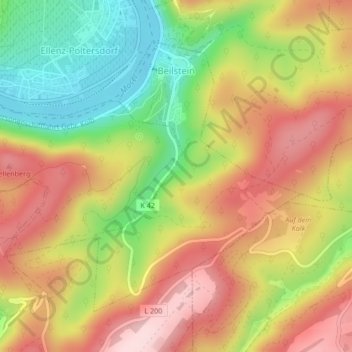
Nom : Carte topographique Beilstein, altitude, relief.
Altitude moyenne : 234 m
Altitude minimum : 80 m
Altitude maximum : 371 m
Autres cartes topographiques
Cliquez sur une carte pour visualiser sa topographie, son altitude et son relief.
Bremm
Duitsland > Rijnland-Palts > Landkreis Cochem-Zell
Bremm, Cochem, Landkreis Cochem-Zell, Rijnland-Palts, Duitsland
Altitude moyenne : 258 m
Roes
Duitsland > Rijnland-Palts > Landkreis Cochem-Zell
Roes, Kaisersesch, Landkreis Cochem-Zell, Rijnland-Palts, Duitsland
Altitude moyenne : 313 m
Neef
Duitsland > Rijnland-Palts > Landkreis Cochem-Zell
Neef, Zell (Mosel), Landkreis Cochem-Zell, Rijnland-Palts, Duitsland
Altitude moyenne : 213 m
Zell (Mosel)
Duitsland > Rijnland-Palts > Landkreis Cochem-Zell
Zell (Mosel), Landkreis Cochem-Zell, Rijnland-Palts, 56856, Duitsland
Altitude moyenne : 287 m
Lutzerath
Duitsland > Rijnland-Palts > Landkreis Cochem-Zell
Lutzerath, Ulmen, Landkreis Cochem-Zell, Rijnland-Palts, 56826, Duitsland
Altitude moyenne : 384 m
Cochem
Duitsland > Rijnland-Palts > Landkreis Cochem-Zell
Cochem, Landkreis Cochem-Zell, Rijnland-Palts, Duitsland
Altitude moyenne : 286 m
Bad Bertrich
Duitsland > Rijnland-Palts > Landkreis Cochem-Zell
Bad Bertrich, Ulmen, Landkreis Cochem-Zell, Rijnland-Palts, 56864, Duitsland
Altitude moyenne : 329 m
Brauheck
Duitsland > Rijnland-Palts > Landkreis Cochem-Zell > Cochem
Brauheck, Cochem, Landkreis Cochem-Zell, Rijnland-Palts, Duitsland
Altitude moyenne : 346 m
Gevenich
Duitsland > Rijnland-Palts > Landkreis Cochem-Zell > Gevenich
Gevenich, Ulmen, Landkreis Cochem-Zell, Rijnland-Palts, Duitsland
Altitude moyenne : 404 m
Ediger-Eller
Duitsland > Rijnland-Palts > Landkreis Cochem-Zell
Ediger-Eller, Cochem, Landkreis Cochem-Zell, Rijnland-Palts, Duitsland
Altitude moyenne : 256 m