
Faire un don
Équipez-vous pour votre prochaine aventure :
En tant que Partenaire Amazon, ce site perçoit une commission sur les achats éligibles sans surcoût pour vous.
Carte topographique Tehatta
Cliquez sur la carte pour afficher l’altitude.
Faire un don
Équipez-vous pour votre prochaine aventure :
En tant que Partenaire Amazon, ce site perçoit une commission sur les achats éligibles sans surcoût pour vous.
Tehatta
Nadia district is mostly alluvial plains lying to the east of Hooghly River, locally known as Bhagirathi. The alluvial plains are cut across by such distributaries as Jalangi, Churni and Ichhamati. With these rivers getting silted up, floods are a recurring feature. The Tehatta subdivision, presented in the map alongside, is topographically part of the Nadia Plain North. The Jalangi River forms the district/ subdivision border in the north-western part and then flows through the subdivision. The other important rivers are Mathabhanga and Bhairab. The eastern portion forms the boundary with Bangladesh. The subdivision is overwhelmingly rural. 97.15% of the population lives in the rural areas and 2.85% lives in the urban areas.
Faire un don
Équipez-vous pour votre prochaine aventure :
En tant que Partenaire Amazon, ce site perçoit une commission sur les achats éligibles sans surcoût pour vous.
À propos de cette carte
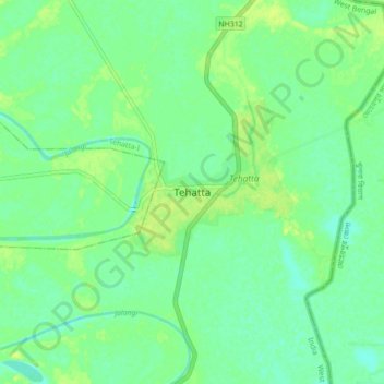
Nom : Carte topographique Tehatta, altitude, relief.
Lieu : Tehatta, Tehatta-I, Nadia, West Bengal, 741160, India (23.57391 88.37336 23.89391 88.69336)
Altitude moyenne : 14 m
Altitude minimum : 6 m
Altitude maximum : 25 m
Faire un don
Équipez-vous pour votre prochaine aventure :
En tant que Partenaire Amazon, ce site perçoit une commission sur les achats éligibles sans surcoût pour vous.