
Faire un don
Équipez-vous pour votre prochaine aventure :
En tant que Partenaire Amazon, ce site perçoit une commission sur les achats éligibles sans surcoût pour vous.
Carte topographique Banner Elk
Cliquez sur la carte pour afficher l’altitude.
Faire un don
Équipez-vous pour votre prochaine aventure :
En tant que Partenaire Amazon, ce site perçoit une commission sur les achats éligibles sans surcoût pour vous.
Banner Elk
Banner Elk is nestled within the Blue Ridge Mountains, characterized by rugged and varied terrain. The town itself sits at an elevation of around 3,700 feet, offering expansive views of the surrounding peaks and valleys. This region, part of the southern Appalachian range, includes steep slopes, dense forests, and high mountain peaks that reach over 5,000 feet in places like Grandfather Mountain nearby. The diverse topography contributes to a cooler-than-typical southern climate, with Banner Elk’s terrain impacting local weather patterns and creating a unique mountain microclimate that often brings snow in winter and cooler, pleasant temperatures in summer. This mountainous terrain is both scenic and functional, supporting outdoor activities such as hiking and skiing, which have become central to Banner Elk’s local culture and tourism.
Faire un don
Équipez-vous pour votre prochaine aventure :
En tant que Partenaire Amazon, ce site perçoit une commission sur les achats éligibles sans surcoût pour vous.
À propos de cette carte
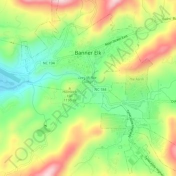
Nom : Carte topographique Banner Elk, altitude, relief.
Lieu : Banner Elk, Avery County, North Carolina, United States (36.13897 -81.88774 36.17356 -81.84810)
Altitude moyenne : 1 165 m
Altitude minimum : 1 036 m
Altitude maximum : 1 332 m
Faire un don
Équipez-vous pour votre prochaine aventure :
En tant que Partenaire Amazon, ce site perçoit une commission sur les achats éligibles sans surcoût pour vous.
Autres cartes topographiques
Cliquez sur une carte pour visualiser sa topographie, son altitude et son relief.
Faire un don
Équipez-vous pour votre prochaine aventure :
En tant que Partenaire Amazon, ce site perçoit une commission sur les achats éligibles sans surcoût pour vous.
Faire un don
Équipez-vous pour votre prochaine aventure :
En tant que Partenaire Amazon, ce site perçoit une commission sur les achats éligibles sans surcoût pour vous.
Beech Mountain
United States > North Carolina > Avery County > Beech Mountain
Beech Mountain is a mountain in the North Carolina High Country and wholly in the Pisgah National Forest. Its elevation reaches 5,506 feet (1,657 m) and generates feeder streams for the Elk River. Nestled on the top is the Town of Beech Mountain.
Altitude moyenne : 1 433 m
Sugar Mountain
United States > North Carolina > Avery County > Sugar Mountain
Sugar Mountain is a mountain in the North Carolina High Country and wholly in the Pisgah National Forest. Its elevation reaches 5,236 feet (1,596 m) and is split along the Eastern Continental Divide, generating feeder streams for the Linville, Elk, and North Toe rivers. On its north slope resides the Village…
Altitude moyenne : 1 385 m
Faire un don
Équipez-vous pour votre prochaine aventure :
En tant que Partenaire Amazon, ce site perçoit une commission sur les achats éligibles sans surcoût pour vous.