
Carte topographique Lake Bullen Merri
Carte interactive
Cliquez sur la carte pour afficher l’altitude.
À propos de cette carte
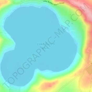
Nom : Carte topographique Lake Bullen Merri, altitude, relief.
Altitude moyenne : 171 m
Altitude minimum : 139 m
Altitude maximum : 281 m
The smaller lake to the north of Lake Bullen Merri has a maximum depth of 20 m (66 ft). The two lakes are linked by an overflow channel in the common wall at an elevation of 175 m. There is a 19th-century record of water from Bullen Merri overflowing into Gnotuk.
Autres cartes topographiques
Cliquez sur une carte pour visualiser sa topographie, son altitude et son relief.
Mount Sugarloaf
Australia > Victoria > Camperdown
Mount Sugarloaf, Camperdown, Shire of Corangamite, Victoria, 3260, Australia
Altitude moyenne : 201 m
Camperdown
Australia > Victoria > Camperdown
Camperdown, Shire of Corangamite, Barwon South West, Victoria, 3260, Australia
Altitude moyenne : 170 m