
Carte topographique Denton
Carte interactive
Cliquez sur la carte pour afficher l’altitude.
À propos de cette carte
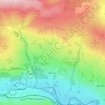
Nom : Carte topographique Denton, altitude, relief.
Altitude moyenne : 189 m
Altitude minimum : 62 m
Altitude maximum : 364 m
Autres cartes topographiques
Cliquez sur une carte pour visualiser sa topographie, son altitude et son relief.
Galphay
United Kingdom > England > North Yorkshire > Harrogate > Galphay
Galphay, Azerley, Harrogate, North Yorkshire, Yorkshire and the Humber, England, HG4 3NJ, United Kingdom
Altitude moyenne : 120 m
Fewston
United Kingdom > England > North Yorkshire > Harrogate > Fewston
Fewston, Harrogate, North Yorkshire, Yorkshire and the Humber, England, United Kingdom
Altitude moyenne : 205 m
Beckwithshaw
United Kingdom > England > North Yorkshire > Harrogate > Beckwithshaw
Beckwithshaw, Harrogate, North Yorkshire, Yorkshire and the Humber, England, HG3 1QW, United Kingdom
Altitude moyenne : 161 m
Bilton-in-Ainsty with Bickerton
United Kingdom > England > North Yorkshire > Harrogate > Bickerton
Bilton-in-Ainsty with Bickerton, Bickerton, Harrogate, North Yorkshire, Yorkshire and the Humber, England, United Kingdom
Altitude moyenne : 28 m