
Faire un don
Équipez-vous pour votre prochaine aventure :
En tant que Partenaire Amazon, ce site perçoit une commission sur les achats éligibles sans surcoût pour vous.
Carte topographique Isle de Jean Charles
Cliquez sur la carte pour afficher l’altitude.
Faire un don
Équipez-vous pour votre prochaine aventure :
En tant que Partenaire Amazon, ce site perçoit une commission sur les achats éligibles sans surcoût pour vous.
À propos de cette carte
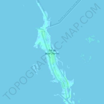
Nom : Carte topographique Isle de Jean Charles, altitude, relief.
Altitude moyenne : 0 m
Altitude minimum : -2 m
Altitude maximum : 4 m
Faire un don
Équipez-vous pour votre prochaine aventure :
En tant que Partenaire Amazon, ce site perçoit une commission sur les achats éligibles sans surcoût pour vous.
Autres cartes topographiques
Cliquez sur une carte pour visualiser sa topographie, son altitude et son relief.
New Orleans
United States > Louisiana > Orleans Parish
Founded in 1718 by French colonists, New Orleans was once the territorial capital of French Louisiana before becoming part of the United States in the Louisiana Purchase of 1803. New Orleans in 1840 was the third most populous city in the United States, and it was the largest city in the American South from…
Altitude moyenne : 1 m
New Orleans
United States > Louisiana > Orleans Parish
New Orleans is situated on relatively flat terrain, primarily at or slightly below sea level, with the average elevation around 6 feet above sea level. The city's landscape is characterized by a network of wetlands, rivers, and bayous, which play a crucial role in its ecology and urban planning. It lies within…
Altitude moyenne : 1 m
Baton Rouge
United States > Louisiana > East Baton Rouge Parish
The city of Baton Rouge lies on the banks of the Mississippi River in southeastern Louisiana's Florida Parishes region. The city is about 79 miles (127 km) from New Orleans, 126 miles (203 km) from Alexandria, 56 miles (90 km) from Lafayette and 250 miles (400 km) from Shreveport. It is also 173 miles (278 km)…
Altitude moyenne : 12 m
Mandeville
United States > Louisiana > St. Tammany Parish
Mandeville is located at 30°22′9″N 90°4′41″W / 30.36917°N 90.07806°W / 30.36917; -90.07806 (30.369282, -90.078006), and has an elevation of 7 feet (2.1 m). According to the United States Census Bureau, the city has a total area of 6.8 square miles (17.7 km2), of which 0.12 square miles…
Altitude moyenne : 6 m
Faire un don
Équipez-vous pour votre prochaine aventure :
En tant que Partenaire Amazon, ce site perçoit une commission sur les achats éligibles sans surcoût pour vous.
Monroe
United States > Louisiana > Ouachita Parish
Located in northeastern Louisiana, Monroe is the center of the Monroe metropolitan statistical area. It is the parish seat of Ouachita Parish, and northeastern Louisiana's economic and cultural hub. Monroe has an elevation of 72 feet (21.9 m) above sea level. According to the United States Census Bureau, the…
Altitude moyenne : 25 m
Lafayette
United States > Louisiana > Lafayette Parish
Lafayette lies approximately 135 miles (217 km) from New Orleans, 59 miles (95 km) from the state capital of Baton Rouge, 75 miles (121 km) from Lake Charles, and 89 miles (143 km) from Alexandria. The city has an elevation ranging from 36 feet (11.0 m) to 49 feet (15 m) above sea level. According to the…
Altitude moyenne : 11 m
Faire un don
Équipez-vous pour votre prochaine aventure :
En tant que Partenaire Amazon, ce site perçoit une commission sur les achats éligibles sans surcoût pour vous.
Kenner
United States > Louisiana > Jefferson Parish
Kenner's coordinates are 30°0′35″N 90°15′2″W / 30.00972°N 90.25056°W / 30.00972; -90.25056 (30.009610, −90.250585) and has an elevation of 0 ft (0 m).
Altitude moyenne : 1 m
Lafayette
United States > Louisiana > Lafayette Parish
Lafayette lies approximately 135 miles (217 km) from New Orleans, 59 miles (95 km) from the state capital of Baton Rouge, 75 miles (121 km) from Lake Charles, and 89 miles (143 km) from Alexandria. The city has an elevation ranging from 36 feet (11.0 m) to 49 feet (15 m) above sea level. According to the…
Altitude moyenne : 11 m
Ponchatoula
United States > Louisiana > Tangipahoa Parish
Ponchatoula is located at 30°26′21″N 90°26′33″W / 30.43917°N 90.44250°W / 30.43917; -90.44250 (30.439162, -90.442507) and has an elevation of 26 feet (7.9 m). According to the United States Census Bureau, the city has a total area of 4.2 square miles (11 km2), all land.
Altitude moyenne : 9 m
Faire un don
Équipez-vous pour votre prochaine aventure :
En tant que Partenaire Amazon, ce site perçoit une commission sur les achats éligibles sans surcoût pour vous.
Faire un don
Équipez-vous pour votre prochaine aventure :
En tant que Partenaire Amazon, ce site perçoit une commission sur les achats éligibles sans surcoût pour vous.
New Roads
United States > Louisiana > Pointe Coupee Parish
New Roads is located at 30°41′47″N 91°26′20″W / 30.69639°N 91.43889°W / 30.69639; -91.43889 (30.696305, -91.438980) and has an elevation of 30 feet (9.1 m).
Altitude moyenne : 10 m
Slidell
United States > Louisiana > St. Tammany Parish
Slidell is located at 30°16′45″N 89°46′40″W / 30.27917°N 89.77778°W / 30.27917; -89.77778 (30.279040, -89.777744), and has an elevation of 13 feet (4.0 m). It is in southeastern St. Tammany Parish, located approximately 3 miles (5 km) north of Lake Pontchartrain. The city forms part of the…
Altitude moyenne : 6 m
Faire un don
Équipez-vous pour votre prochaine aventure :
En tant que Partenaire Amazon, ce site perçoit une commission sur les achats éligibles sans surcoût pour vous.
Faire un don
Équipez-vous pour votre prochaine aventure :
En tant que Partenaire Amazon, ce site perçoit une commission sur les achats éligibles sans surcoût pour vous.
Faire un don
Équipez-vous pour votre prochaine aventure :
En tant que Partenaire Amazon, ce site perçoit une commission sur les achats éligibles sans surcoût pour vous.
Faire un don
Équipez-vous pour votre prochaine aventure :
En tant que Partenaire Amazon, ce site perçoit une commission sur les achats éligibles sans surcoût pour vous.
Faire un don
Équipez-vous pour votre prochaine aventure :
En tant que Partenaire Amazon, ce site perçoit une commission sur les achats éligibles sans surcoût pour vous.
Faire un don
Équipez-vous pour votre prochaine aventure :
En tant que Partenaire Amazon, ce site perçoit une commission sur les achats éligibles sans surcoût pour vous.
Faire un don
Équipez-vous pour votre prochaine aventure :
En tant que Partenaire Amazon, ce site perçoit une commission sur les achats éligibles sans surcoût pour vous.
Faire un don
Équipez-vous pour votre prochaine aventure :
En tant que Partenaire Amazon, ce site perçoit une commission sur les achats éligibles sans surcoût pour vous.
Faire un don
Équipez-vous pour votre prochaine aventure :
En tant que Partenaire Amazon, ce site perçoit une commission sur les achats éligibles sans surcoût pour vous.
Faire un don
Équipez-vous pour votre prochaine aventure :
En tant que Partenaire Amazon, ce site perçoit une commission sur les achats éligibles sans surcoût pour vous.
Faire un don
Équipez-vous pour votre prochaine aventure :
En tant que Partenaire Amazon, ce site perçoit une commission sur les achats éligibles sans surcoût pour vous.
LaPlace
United States > Louisiana > St. John the Baptist Parish > LaPlace
LaPlace is located at 30°4′30″N 90°29′6″W / 30.07500°N 90.48500°W / 30.07500; -90.48500 (30.075025, -90.484896) and has an elevation of 10 feet (3.0 m).
Altitude moyenne : 3 m
Faire un don
Équipez-vous pour votre prochaine aventure :
En tant que Partenaire Amazon, ce site perçoit une commission sur les achats éligibles sans surcoût pour vous.
Bienville Parish
The highest natural point in Louisiana, a hill known as Mt. Driskill, 535 feet (163 m) in elevation, is located in north central Bienville Parish. The mountain is located on private land with public access by walking trail. It is named for James Christopher Driskill, a 19th-century landowner. Nearby is Jordan…
Altitude moyenne : 72 m
Baton Rouge
United States > Louisiana > East Baton Rouge Parish
Baton Rouge is on the banks of the Mississippi River in southeastern Louisiana's Florida Parishes region. The city is about 79 miles (127 km) from New Orleans, 126 miles (203 km) from Alexandria, 56 miles (90 km) from Lafayette and 250 miles (400 km) from Shreveport. It is also 173 miles (278 km) from Jackson,…
Altitude moyenne : 12 m
Faire un don
Équipez-vous pour votre prochaine aventure :
En tant que Partenaire Amazon, ce site perçoit une commission sur les achats éligibles sans surcoût pour vous.
Lake Charles
United States > Louisiana > Calcasieu Parish
Lake Charles, located on a level plain about 30 miles (48 km) from the Gulf of Mexico, has an elevation of approximately 13 feet (4.0 m) above sea level, and is located on the banks of the Calcasieu River in southwestern Louisiana. It borders both Lake Charles and Prien Lake. Contraband Bayou, Henderson Bayou,…
Altitude moyenne : 5 m
Houma
United States > Louisiana > Terrebonne Parish
Houma is located at 29°35′15″N 90°42′58″W / 29.58750°N 90.71611°W / 29.58750; -90.71611 (29.587614, -90.716108) and has an elevation of 10 feet (3.0 m) above sea level. According to the United States Census Bureau, the city has a total area of 14.2 square miles (37 km2), of which 14.0…
Altitude moyenne : 3 m
Bogalusa
United States > Louisiana > Washington Parish
Bogalusa has an elevation of 100 feet (30.5 m).
Altitude moyenne : 29 m
Faire un don
Équipez-vous pour votre prochaine aventure :
En tant que Partenaire Amazon, ce site perçoit une commission sur les achats éligibles sans surcoût pour vous.
Shreveport
United States > Louisiana > Caddo Parish
Shreveport is the parish seat of Caddo Parish. Portions of the city extend into neighboring Bossier Parish, bordering Bossier City. Shreveport sits on a low elevation overlooking the Red River. Western and northern portions of Shreveport have an elevation over 253 feet (77 m) above sea level. Pine forests,…
Altitude moyenne : 58 m
Faire un don
Équipez-vous pour votre prochaine aventure :
En tant que Partenaire Amazon, ce site perçoit une commission sur les achats éligibles sans surcoût pour vous.
Lake Charles
United States > Louisiana > Calcasieu Parish
Lake Charles, located on a level plain about 30 miles (48 km) from the Gulf of Mexico, has an elevation of approximately 13 feet (4.0 m) above sea level, and is located on the banks of the Calcasieu River in southwestern Louisiana. It borders both Lake Charles and Prien Lake. Contraband Bayou, Henderson Bayou,…
Altitude moyenne : 5 m
Faire un don
Équipez-vous pour votre prochaine aventure :
En tant que Partenaire Amazon, ce site perçoit une commission sur les achats éligibles sans surcoût pour vous.
Faire un don
Équipez-vous pour votre prochaine aventure :
En tant que Partenaire Amazon, ce site perçoit une commission sur les achats éligibles sans surcoût pour vous.
Faire un don
Équipez-vous pour votre prochaine aventure :
En tant que Partenaire Amazon, ce site perçoit une commission sur les achats éligibles sans surcoût pour vous.
Faire un don
Équipez-vous pour votre prochaine aventure :
En tant que Partenaire Amazon, ce site perçoit une commission sur les achats éligibles sans surcoût pour vous.
Carencro
United States > Louisiana > Lafayette Parish
Carencro is located at 30°18′51″N 92°2′37″W / 30.31417°N 92.04361°W / 30.31417; -92.04361 (30.314232, -92.043614) and has an elevation of 39 feet (11.9 m). According to the United States Census Bureau, the city has a total area of 6.1 square miles (16 km2), all land.
Altitude moyenne : 15 m
Faire un don
Équipez-vous pour votre prochaine aventure :
En tant que Partenaire Amazon, ce site perçoit une commission sur les achats éligibles sans surcoût pour vous.
Faire un don
Équipez-vous pour votre prochaine aventure :
En tant que Partenaire Amazon, ce site perçoit une commission sur les achats éligibles sans surcoût pour vous.