
Faire un don
Équipez-vous pour votre prochaine aventure :
En tant que Partenaire Amazon, ce site perçoit une commission sur les achats éligibles sans surcoût pour vous.
Carte topographique Hiko
Cliquez sur la carte pour afficher l’altitude.
Faire un don
Équipez-vous pour votre prochaine aventure :
En tant que Partenaire Amazon, ce site perçoit une commission sur les achats éligibles sans surcoût pour vous.
Hiko
The Hiko and Crystal Springs provide a large supply of water for the Hiko farms and ranches. The Hiko farming community is located in the north end of the Pahranagat Valley and lies at an elevation of 3,869 feet (1,179 m), with a ZIP code of 89017.
Faire un don
Équipez-vous pour votre prochaine aventure :
En tant que Partenaire Amazon, ce site perçoit une commission sur les achats éligibles sans surcoût pour vous.
À propos de cette carte
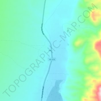
Nom : Carte topographique Hiko, altitude, relief.
Lieu : Hiko, Lincoln County, Nevada, United States (37.57606 -115.24424 37.61606 -115.20424)
Altitude moyenne : 1 233 m
Altitude minimum : 1 169 m
Altitude maximum : 1 505 m
Faire un don
Équipez-vous pour votre prochaine aventure :
En tant que Partenaire Amazon, ce site perçoit une commission sur les achats éligibles sans surcoût pour vous.
Autres cartes topographiques
Cliquez sur une carte pour visualiser sa topographie, son altitude et son relief.
Caliente
United States > Nevada > Lincoln County
Caliente /kæliˈɛni/, /kæliˈɛnti/, formerly known as Culverwell and Calientes, is a city in Lincoln County, Nevada, United States. Its elevation is 4,300 feet (1,300 m). The population was 1,130 at the 2010 census, making it the least populated incorporated city in Nevada. The city's name originated from…
Altitude moyenne : 1 439 m
Caliente
United States > Nevada > Lincoln County
Caliente has a high-desert climate typical for a location around 4,000 feet (1,200 m) in elevation. Winters are chilly, but only moderately cold. Summers are characterized by blazing sunshine, long days, cool nights, and high diurnal temperature range. January highs average in the mid 40s, while July averages…
Altitude moyenne : 1 446 m
Faire un don
Équipez-vous pour votre prochaine aventure :
En tant que Partenaire Amazon, ce site perçoit une commission sur les achats éligibles sans surcoût pour vous.