Géolocaliser

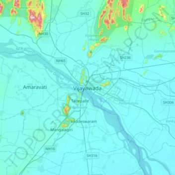
Carte topographique Vijayawada

Cliquez sur la carte pour afficher l’altitude.

Vijayawada

Vijayawada lies on the banks of Krishna river, covered by hills and canals. and at an altitude of 11 m (36 ft) above sea level. Three canals originating from the north side of the Prakasam Barrage reservoir — Eluru, Bandar, and Ryves — flow through the city.

Wikipedia (CC-BY-SA 3.0)

À propos de cette carte

Nom : Carte topographique Vijayawada, altitude, relief.

Lieu : Vijayawada, Vijayawada (Urban), NTR, Andhra Pradesh, 520001, India (16.35153 80.45605 16.67153 80.77605)

Altitude moyenne : 37 m

Altitude minimum : 7 m

Altitude maximum : 448 m

Équipez-vous pour votre prochaine aventure :

👜Sacoche de Guidon - Gardez votre carte ou smartphone sous les yeux à vélo.
🧢Tours de cou multifonctions - Protection contre froid et vent
📦Sacs de Compression - Optimisez l'espace et gardez vos vêtements au sec.
🔥Pierre à Feu - Allumez un feu de camp en toute condition.
🍼Gourde Isotherme - Garde vos boissons fraîches ou chaudes pendant 24 heures.

En tant que Partenaire Amazon, ce site perçoit une commission sur les achats éligibles sans surcoût pour vous.