
Faire un don
Équipez-vous pour votre prochaine aventure :
En tant que Partenaire Amazon, ce site perçoit une commission sur les achats éligibles sans surcoût pour vous.
Carte topographique Loxahatchee Groves
Cliquez sur la carte pour afficher l’altitude.
Faire un don
Équipez-vous pour votre prochaine aventure :
En tant que Partenaire Amazon, ce site perçoit une commission sur les achats éligibles sans surcoût pour vous.
Loxahatchee Groves
The area now known as Loxahatchee Groves was originally a portion of the 2,000,000 acres (8,100 km2) of land purchased by the Southern States Land and Timber Company in 1902. After the West Palm Beach Canal (C-51), which connected Lake Okeechobee at Canal Point to West Palm Beach, was completed in 1917, George Frederick Bensel, the Southern States sales manager, envisioned a "waterfront" farming community along the canal. Bensel, and company engineer Torvald Garfield "T. G." Thorgesen, created the first topographical map of Loxahatchee Groves during the following three years. Bensel, Thorgesen, and others then established the Palm Beach Loxahatchee Company, and bought 6,500 acres (26 km2) from the Southern States Land and Timber Company, naming the land "Loxahatchee Farms". The Palm Beach Loxahatchee Company built almost 30 mi (48 km) of canals and roads, which were to be maintained by the Loxahatchee Groves Drainage District, that now is known as the Loxahatchee Groves Water Control District.
Faire un don
Équipez-vous pour votre prochaine aventure :
En tant que Partenaire Amazon, ce site perçoit une commission sur les achats éligibles sans surcoût pour vous.
À propos de cette carte
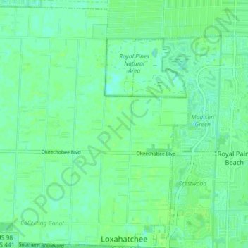
Nom : Carte topographique Loxahatchee Groves, altitude, relief.
Altitude moyenne : 9 m
Altitude minimum : 4 m
Altitude maximum : 12 m
Faire un don
Équipez-vous pour votre prochaine aventure :
En tant que Partenaire Amazon, ce site perçoit une commission sur les achats éligibles sans surcoût pour vous.
Autres cartes topographiques
Cliquez sur une carte pour visualiser sa topographie, son altitude et son relief.
Faire un don
Équipez-vous pour votre prochaine aventure :
En tant que Partenaire Amazon, ce site perçoit une commission sur les achats éligibles sans surcoût pour vous.
Faire un don
Équipez-vous pour votre prochaine aventure :
En tant que Partenaire Amazon, ce site perçoit une commission sur les achats éligibles sans surcoût pour vous.
Faire un don
Équipez-vous pour votre prochaine aventure :
En tant que Partenaire Amazon, ce site perçoit une commission sur les achats éligibles sans surcoût pour vous.
Faire un don
Équipez-vous pour votre prochaine aventure :
En tant que Partenaire Amazon, ce site perçoit une commission sur les achats éligibles sans surcoût pour vous.
Delray Beach
United States > Florida > Palm Beach County > Delray Beach
Delray Beach has hot and humid summers. High summertime temperatures range from 87-93 °F with low temperatures around 75-78 °F. Winters are warm, with a marked drier season. Typical wintertime high temperatures are typically in the range of 74-83 °F and low temperatures 57-65 °F. However, when occasional…
Altitude moyenne : 4 m
Villages of Oriole
United States > Florida > Palm Beach County > Villages of Oriole
Altitude moyenne : 9 m
Faire un don
Équipez-vous pour votre prochaine aventure :
En tant que Partenaire Amazon, ce site perçoit une commission sur les achats éligibles sans surcoût pour vous.
Blue Inlet
United States > Florida > Palm Beach County > Boca Raton > Blue Inlet
Altitude moyenne : 4 m
Oslo national park
United States > Florida > Palm Beach County > West Palm Beach
Altitude moyenne : 9 m
Faire un don
Équipez-vous pour votre prochaine aventure :
En tant que Partenaire Amazon, ce site perçoit une commission sur les achats éligibles sans surcoût pour vous.