
Faire un don
Équipez-vous pour votre prochaine aventure :
En tant que Partenaire Amazon, ce site perçoit une commission sur les achats éligibles sans surcoût pour vous.
Carte topographique Northcutts Cove
Cliquez sur la carte pour afficher l’altitude.
Faire un don
Équipez-vous pour votre prochaine aventure :
En tant que Partenaire Amazon, ce site perçoit une commission sur les achats éligibles sans surcoût pour vous.
À propos de cette carte
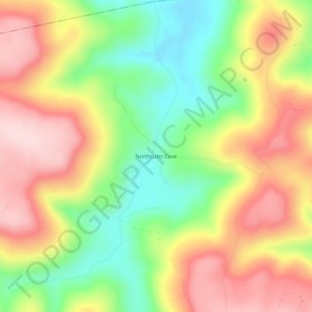
Nom : Carte topographique Northcutts Cove, altitude, relief.
Altitude moyenne : 454 m
Altitude minimum : 305 m
Altitude maximum : 601 m
Faire un don
Équipez-vous pour votre prochaine aventure :
En tant que Partenaire Amazon, ce site perçoit une commission sur les achats éligibles sans surcoût pour vous.
Autres cartes topographiques
Cliquez sur une carte pour visualiser sa topographie, son altitude et son relief.
Monteagle
United States > Tennessee > Grundy County
The town straddles a narrow stretch of the Cumberland Plateau known colloquially as "Monteagle Mountain". This stretch of the plateau is approximately 2 miles (3 km) wide, with steep drop-offs to the northwest and southeast. Monteagle lies at an elevation of just under 2,000 feet (610 m) above sea level. By…
Altitude moyenne : 487 m
Faire un don
Équipez-vous pour votre prochaine aventure :
En tant que Partenaire Amazon, ce site perçoit une commission sur les achats éligibles sans surcoût pour vous.
Altamont
United States > Tennessee > Grundy County
Altamont was established in 1848 as a county seat for Grundy County, which had been created in 1844. General Adrian Northcutt, a prominent local farmer and military officer, was the prime advocate for the site's selection. The town's name comes from combining alto (meaning "altitude") and mont (meaning…
Altitude moyenne : 565 m
Monteagle
United States > Tennessee > Grundy County
The town straddles a narrow stretch of the Cumberland Plateau known colloquially as "Monteagle Mountain". This stretch of the plateau is approximately 2 miles (3 km) wide, with steep drop-offs to the northwest and southeast. Monteagle lies at an elevation of just under 2,000 feet (610 m) above sea level. By…
Altitude moyenne : 507 m