
Carte topographique Oed
Cliquez sur la carte pour afficher l’altitude.
À propos de cette carte
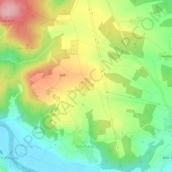
Nom : Carte topographique Oed, altitude, relief.
Altitude moyenne : 411 m
Altitude minimum : 341 m
Altitude maximum : 504 m
Autres cartes topographiques
Cliquez sur une carte pour visualiser sa topographie, son altitude et son relief.
Obermainsbach
Deutschland > Bayern > Landkreis Schwandorf > Nittenau > Bleich
Altitude moyenne : 385 m
Hof am Regen
Deutschland > Bayern > Landkreis Schwandorf > Nittenau > Hof am Regen
Altitude moyenne : 418 m
Stefling
Deutschland > Bayern > Landkreis Schwandorf > Nittenau
Annahaid | Asang | Auhof | Bachbügl | Bergham | Berghof | Berglarn | Bleich | Bodenstein | Brunn | Diepenried | Dobl | Dürrmaul | Eckartsreuth | Eichlgütl | Elendhof | Entermainsbach | Eschlbach | Fichtenhof | Fischbach | Forsting | Geiseck | Goppeltshof | Gunt | Hadriwa (Nittenau) | Haiderhöf |…
Altitude moyenne : 429 m
Vorderkohlstetten
Deutschland > Bayern > Landkreis Schwandorf > Nittenau > Hof am Regen
Altitude moyenne : 429 m