
Carte topographique Warm Springs
Carte interactive
Cliquez sur la carte pour afficher l’altitude.
À propos de cette carte
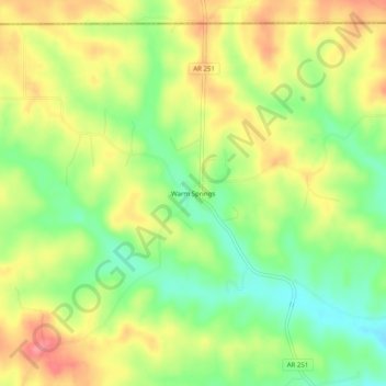
Nom : Carte topographique Warm Springs, altitude, relief.
Altitude moyenne : 148 m
Altitude minimum : 106 m
Altitude maximum : 191 m
Autres cartes topographiques
Cliquez sur une carte pour visualiser sa topographie, son altitude et son relief.
Sand Hill
United States > Arkansas > Randolph County > Pocahontas
Sand Hill, Pocahontas, Randolph County, Arkansas, 72455, United States
Altitude moyenne : 118 m
Maynard
United States > Arkansas > Randolph County
Maynard, Randolph County, Arkansas, 72444, United States
Altitude moyenne : 128 m
O'Kean
United States > Arkansas > Randolph County
O'Kean, Randolph County, Arkansas, 72425, United States
Altitude moyenne : 82 m
Pocahontas
United States > Arkansas > Randolph County > Pocahontas
Pocahontas, Randolph County, Arkansas, United States
Altitude moyenne : 96 m
Pocahontas
United States > Arkansas > Randolph County > Pocahontas
Pocahontas, Randolph County, Arkansas, 72455, United States
Altitude moyenne : 94 m
O"Kean
United States > Arkansas > Randolph County > O"Kean
O"Kean, Randolph County, Arkansas, 72425, United States
Altitude moyenne : 82 m