
Carte topographique Dahn
Carte interactive
Cliquez sur la carte pour afficher l’altitude.
À propos de cette carte
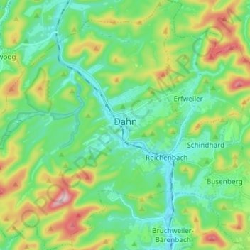
Nom : Carte topographique Dahn, altitude, relief.
Altitude moyenne : 286 m
Altitude minimum : 194 m
Altitude maximum : 511 m
Autres cartes topographiques
Cliquez sur une carte pour visualiser sa topographie, son altitude et son relief.
Ludwigswinkel
Duitsland > Rijnland-Palts > Südwestpfalz
Ludwigswinkel, Dahner Felsenland, Südwestpfalz, Rijnland-Palts, Duitsland
Altitude moyenne : 303 m
Ransberg
Duitsland > Rijnland-Palts > Südwestpfalz > Eppenbrunn
Ransberg, Eppenbrunn, Pirmasens-Land, Südwestpfalz, Rijnland-Palts, 66957, Duitsland
Altitude moyenne : 367 m