
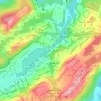
Carte topographique Shongum Lake Dam
Carte interactive
Cliquez sur la carte pour afficher l’altitude.
À propos de cette carte
Nom : Carte topographique Shongum Lake Dam, altitude, relief.
Altitude moyenne : 255 m
Altitude minimum : 199 m
Altitude maximum : 316 m
Autres cartes topographiques
Cliquez sur une carte pour visualiser sa topographie, son altitude et son relief.
Lake Cherokee
United States > New Jersey > Morris County > Randolph Township > Calais Crossroads
Lake Cherokee, Calais Crossroads, Randolph Township, Morris County, New Jersey, United States
Altitude moyenne : 295 m
Mill Brook
United States > New Jersey > Morris County > Randolph Township
Mill Brook, Randolph Township, Morris County, New Jersey, 07801, United States
Altitude moyenne : 241 m
Ironia
United States > New Jersey > Morris County > Randolph Township
Ironia, Randolph Township, Morris County, New Jersey, 07876, United States
Altitude moyenne : 260 m
Coleman Hollow
United States > New Jersey > Morris County > Randolph Township > Coleman Hollow
Coleman Hollow, Randolph Township, Morris County, New Jersey, 07845, United States
Altitude moyenne : 263 m