
Carte topographique Stephens County
Carte interactive
Cliquez sur la carte pour afficher l’altitude.
À propos de cette carte
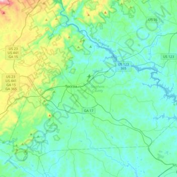
Nom : Carte topographique Stephens County, altitude, relief.
Lieu : Stephens County, Georgia, United States (34.46030 -83.45979 34.68720 -83.10331)
Altitude moyenne : 299 m
Altitude minimum : 197 m
Altitude maximum : 777 m
According to the U.S. Census Bureau, the county has a total area of 184 square miles (480 km2), of which 179 square miles (460 km2) is land and 5.1 square miles (13 km2) (2.8%) is water. The county is located mainly within the upper Piedmont region of the state, with western portions of the county having the highest elevations and located in the foothills of the Blue Ridge Mountains.
Autres cartes topographiques
Cliquez sur une carte pour visualiser sa topographie, son altitude et son relief.
Cumming
United States > Georgia > Forsyth County
Cumming, Forsyth County, Georgia, United States
Altitude moyenne : 365 m
Marietta
United States > Georgia > Cobb County
Marietta, Cobb County, Georgia, United States
Altitude moyenne : 323 m
Leesburg
United States > Georgia > Lee County
Leesburg, Lee County, Georgia, United States
Altitude moyenne : 76 m
Hoschton
United States > Georgia > Jackson County
Hoschton, Jackson County, Georgia, United States
Altitude moyenne : 263 m
Roswell
United States > Georgia > Fulton County
Roswell, Fulton County, Georgia, United States
Altitude moyenne : 316 m
Union City
United States > Georgia > Fulton County
Union City, Fulton County, Georgia, United States
Altitude moyenne : 284 m
Treutlen County
Treutlen County, Georgia, 30457, United States
Altitude moyenne : 75 m
Chattahoochee County
United States > Georgia > Chattahoochee County
Chattahoochee County, Georgia, United States
Altitude moyenne : 123 m
Norman Park
United States > Georgia > Colquitt County
Norman Park, Colquitt County, Georgia, United States
Altitude moyenne : 100 m
Augusta Canal
United States > Georgia > Richmond County > Augusta
Augusta Canal, Augusta, Richmond County, Georgia, United States
Altitude moyenne : 80 m
Ben Hill County
Ben Hill County, Georgia, 31750, United States
Altitude moyenne : 88 m
Jasper
United States > Georgia > Pickens County
Jasper, Pickens County, Georgia, 30142, United States
Altitude moyenne : 408 m
Brunswick
United States > Georgia > Glynn County
Brunswick, Glynn County, Georgia, United States
Altitude moyenne : 2 m
Norwood
United States > Georgia > Warren County
Norwood, Warren County, Georgia, United States
Altitude moyenne : 180 m
Kentucky Island
United States > Georgia > Wayne County
Kentucky Island, Wayne County, Georgia, United States
Altitude moyenne : 19 m
Chatsworth
United States > Georgia > Murray County
Chatsworth, Murray County, Georgia, United States
Altitude moyenne : 241 m
Aboretum
United States > Georgia > Cobb County
Aboretum, Cobb County, Georgia, United States
Altitude moyenne : 319 m
Shake Rag
United States > Georgia > Fulton County > Johns Creek
Shake Rag, Johns Creek, Fulton County, Georgia, 30095, United States
Altitude moyenne : 300 m
Colony South
United States > Georgia > Hall County
Colony South, Hall County, Georgia, United States
Altitude moyenne : 328 m
Huntington Place
United States > Georgia > Fayette County > Peachtree City
Huntington Place, Peachtree City, Fayette County, Georgia, 30269, United States
Altitude moyenne : 249 m
Dorchester
United States > Georgia > Richmond County > Augusta
Dorchester, Augusta, Richmond County, Georgia, 30909, United States
Altitude moyenne : 90 m
Emerson Park
United States > Georgia > Ware County
Emerson Park, Ware County, Georgia, 31503, United States
Altitude moyenne : 44 m
Bamburg
United States > Georgia > Echols County
Bamburg, Echols County, Georgia, United States
Altitude moyenne : 48 m
Haralson County
Haralson County, Georgia, United States
Altitude moyenne : 353 m
Bamboo Forest
United States > Georgia > Fulton County > Sandy Springs
Bamboo Forest, Sandy Springs, Fulton County, Georgia, 30339, United States
Altitude moyenne : 278 m
Chapel Hill
United States > Georgia > Douglas County
Chapel Hill, Douglas County, Georgia, 30135, United States
Altitude moyenne : 296 m
Winston
United States > Georgia > Douglas County
Winston, Douglas County, Georgia, 30187, United States
Altitude moyenne : 340 m
Buford
United States > Georgia > Gwinnett County
Buford, Gwinnett County, Georgia, United States
Altitude moyenne : 340 m
Holmesville
United States > Georgia > Appling County
Holmesville, Appling County, Georgia, United States
Altitude moyenne : 55 m
Juno
United States > Georgia > Dawson County
Juno, Dawson County, Georgia, United States
Altitude moyenne : 454 m
Tyree
United States > Georgia > Douglas County
Tyree, Douglas County, Georgia, United States
Altitude moyenne : 346 m
Velta
United States > Georgia > Rockdale County
Velta, Rockdale County, Georgia, 30094, United States
Altitude moyenne : 235 m
Effingham County
Effingham County, Georgia, United States
Altitude moyenne : 21 m
White Cliffs
United States > Georgia > Gilmer County
White Cliffs, Gilmer County, Georgia, United States
Altitude moyenne : 833 m
Emerson
United States > Georgia > Bartow County
Emerson, Bartow County, Georgia, 30137, United States
Altitude moyenne : 254 m
Ball Ground
United States > Georgia > Cherokee County
Ball Ground, Cherokee County, Georgia, United States
Altitude moyenne : 331 m
Commerce
United States > Georgia > Jackson County
Commerce, Jackson County, Georgia, United States
Altitude moyenne : 252 m
Washington County
Washington County, Georgia, United States
Altitude moyenne : 113 m