
Carte topographique Littleton
Carte interactive
Cliquez sur la carte pour afficher l’altitude.
À propos de cette carte
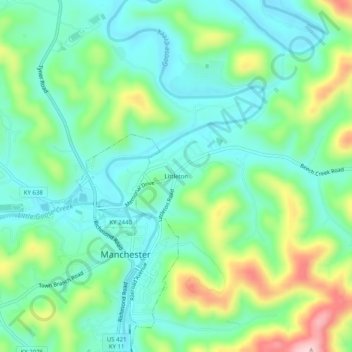
Nom : Carte topographique Littleton, altitude, relief.
Lieu : Littleton, Clay County, Kentucky, 40962, United States (37.14259 -83.77464 37.18259 -83.73464)
Altitude moyenne : 315 m
Altitude minimum : 246 m
Altitude maximum : 484 m
Autres cartes topographiques
Cliquez sur une carte pour visualiser sa topographie, son altitude et son relief.
Oneida
United States > Kentucky > Clay County
Oneida, Clay County, Kentucky, United States
Altitude moyenne : 297 m
Sextons Creek
United States > Kentucky > Clay County
Sextons Creek, Clay County, Kentucky, 40983, United States
Altitude moyenne : 311 m
Big Creek
United States > Kentucky > Clay County
Big Creek, Clay County, Kentucky, 40914, United States
Altitude moyenne : 354 m
Fall Rock
United States > Kentucky > Clay County
Fall Rock, Clay County, Kentucky, United States
Altitude moyenne : 344 m
Manchester
United States > Kentucky > Clay County
Manchester, Clay County, Kentucky, 40962, United States
Altitude moyenne : 315 m
Vine
United States > Kentucky > Clay County
Vine, Clay County, Kentucky, United States
Altitude moyenne : 335 m