
Faire un don
Équipez-vous pour votre prochaine aventure :
En tant que Partenaire Amazon, ce site perçoit une commission sur les achats éligibles sans surcoût pour vous.
Carte topographique Prayagraj
Cliquez sur la carte pour afficher l’altitude.
Faire un don
Équipez-vous pour votre prochaine aventure :
En tant que Partenaire Amazon, ce site perçoit une commission sur les achats éligibles sans surcoût pour vous.
Prayagraj
Prayagraj's elevation is over 90 m (295 ft) above sea level. The old part of the city, at the south of Prayagraj Junction railway station, consists of neighbourhoods like Chowk, Johnstongunj, Dariyabad, Khuldabad and many more. In the north of the Railway Station, the new city consists of neighbourhoods like Lukergunj, Civil Lines, Georgetown, Tagoretown, Allahpur, Ashok Nagar, Mumfordgunj, Bharadwaj Puram and others which are relatively new and were built during the British rule. Civil Lines is the central business district of the city and is famous for its urban setting, gridiron plan roads and high rise buildings. Built in 1857, it was the largest town-planning project carried out in India before the establishment of New Delhi. Prayagraj has many buildings featuring Indo-Islamic and Indo-Saracenic architecture. Although several buildings from the colonial period have been declared "heritage structures", others are deteriorating. Famous landmarks of the city are Allahabad Museum, New Yamuna Bridge, Allahabad University, Triveni Sangam, All Saints Cathedral, Anand Bhavan, Chandrashekhar Azad Park etc. The city experiences one of the highest levels of air pollution worldwide, with the 2016 update of the World Health Organization's Global Urban Ambient Air Pollution Database finding Prayagraj to have the third highest mean concentration of "PM2.5" (<2.5 μm diameter) particulate matter in the ambient air among all the 2972 cities tested (after Zabol and Gwalior).
Faire un don
Équipez-vous pour votre prochaine aventure :
En tant que Partenaire Amazon, ce site perçoit une commission sur les achats éligibles sans surcoût pour vous.
À propos de cette carte
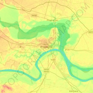
Nom : Carte topographique Prayagraj, altitude, relief.
Lieu : Prayagraj, Uttar Pradesh, 211001, India (25.27813 81.67380 25.59813 81.99380)
Altitude moyenne : 91 m
Altitude minimum : 66 m
Altitude maximum : 120 m
Faire un don
Équipez-vous pour votre prochaine aventure :
En tant que Partenaire Amazon, ce site perçoit une commission sur les achats éligibles sans surcoût pour vous.