
Faire un don
Équipez-vous pour votre prochaine aventure :
En tant que Partenaire Amazon, ce site perçoit une commission sur les achats éligibles sans surcoût pour vous.
Carte topographique Givat Yoav
Cliquez sur la carte pour afficher l’altitude.
Faire un don
Équipez-vous pour votre prochaine aventure :
En tant que Partenaire Amazon, ce site perçoit une commission sur les achats éligibles sans surcoût pour vous.
À propos de cette carte
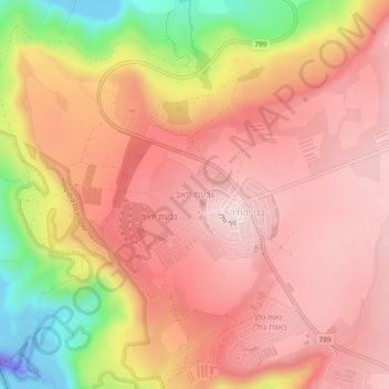
Nom : Carte topographique Givat Yoav, altitude, relief.
Altitude moyenne : 245 m
Altitude minimum : -111 m
Altitude maximum : 370 m
Faire un don
Équipez-vous pour votre prochaine aventure :
En tant que Partenaire Amazon, ce site perçoit une commission sur les achats éligibles sans surcoût pour vous.
Autres cartes topographiques
Cliquez sur une carte pour visualiser sa topographie, son altitude et son relief.
Nimrod Fortress National Park
Israel > North District > Golan Regional Council
Altitude moyenne : 674 m
Yehudia - Brechat HaMeshushim Site Nature Reserve
Israel > North District > Golan Regional Council
Altitude moyenne : 91 m
Faire un don
Équipez-vous pour votre prochaine aventure :
En tant que Partenaire Amazon, ce site perçoit une commission sur les achats éligibles sans surcoût pour vous.
El Rom
Israel > North District > Golan Regional Council
The kibbutz is about ten kilometers (6.2 mi) south of Mount Hermon, at an elevation of 1,050–1,070 meters (3,440–3,510 ft) above sea level. El Rom and the nearby moshav Odem are the two Jewish settlements in Israel with the highest elevation after Nimrod.
Altitude moyenne : 1 062 m
Avnay Eitan
Israel > North District > Golan Regional Council
Avnei Eitan (Hebrew: אַבְנֵי אֵיתָן) is an Israeli settlement organized as a moshav in the southern Golan Heights, located at an elevation of 385 meters (1,263 ft) above sea level. Located to the east of the Sea of Galilee, it falls under the municipal jurisdiction of Golan Regional Council. In…
Altitude moyenne : 384 m
Faire un don
Équipez-vous pour votre prochaine aventure :
En tant que Partenaire Amazon, ce site perçoit une commission sur les achats éligibles sans surcoût pour vous.
Faire un don
Équipez-vous pour votre prochaine aventure :
En tant que Partenaire Amazon, ce site perçoit une commission sur les achats éligibles sans surcoût pour vous.