
Carte topographique Bryan County
Carte interactive
Cliquez sur la carte pour afficher l’altitude.
À propos de cette carte
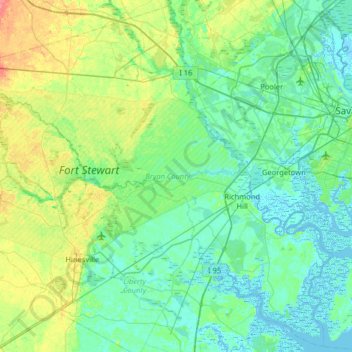
Nom : Carte topographique Bryan County, altitude, relief.
Lieu : Bryan County, Georgia, United States (31.71266 -81.78175 32.24118 -81.13832)
Altitude moyenne : 13 m
Altitude minimum : -4 m
Altitude maximum : 59 m
Autres cartes topographiques
Cliquez sur une carte pour visualiser sa topographie, son altitude et son relief.
The Lakes
United States > Georgia > Camden County > Kingsland
The Lakes, Kingsland, Camden County, Georgia, 31548, United States
Altitude moyenne : 7 m
Orchard Hill
United States > Georgia > Spalding County
Orchard Hill, Spalding County, Georgia, United States
Altitude moyenne : 253 m
Valdosta
United States > Georgia > Lowndes County
Valdosta, Lowndes County, Georgia, United States
Altitude moyenne : 58 m
South Fulton
United States > Georgia > Fulton County
South Fulton, Fulton County, Georgia, United States
Altitude moyenne : 272 m
Gwinnett County
Gwinnett County, Georgia, United States
Altitude moyenne : 302 m
Taylor Lake Dam South
United States > Georgia > Calhoun County
Taylor Lake Dam South, Calhoun County, Georgia, 39866, United States
Altitude moyenne : 68 m
Whitesburg
United States > Georgia > Carroll County
Whitesburg, Carroll County, Georgia, United States
Altitude moyenne : 249 m
Chattahoochee Hills
United States > Georgia > Fulton County
Chattahoochee Hills, Fulton County, Georgia, United States
Altitude moyenne : 261 m
Piney Bluff
United States > Georgia > Camden County
Piney Bluff, Camden County, Georgia, United States
Altitude moyenne : 2 m
Thompson Dam
United States > Georgia > Dooly County
Thompson Dam, Dooly County, Georgia, United States
Altitude moyenne : 123 m
Darien
United States > Georgia > McIntosh County
Darien, McIntosh County, Georgia, 31305, United States
Altitude moyenne : 3 m
Senoia
United States > Georgia > Coweta County
Senoia, Coweta County, Georgia, United States
Altitude moyenne : 248 m
Hiram
United States > Georgia > Paulding County
Hiram, Paulding County, Georgia, United States
Altitude moyenne : 306 m
Nevils
United States > Georgia > Bulloch County
Nevils, Bulloch County, Georgia, United States
Altitude moyenne : 51 m
Douglasville
United States > Georgia > Douglas County
Douglasville, Douglas County, Georgia, 30133, United States
Altitude moyenne : 310 m
Pennant Hill
United States > Georgia > Glynn County
Pennant Hill, Glynn County, Georgia, United States
Altitude moyenne : 5 m
Norman Park
United States > Georgia > Colquitt County
Norman Park, Colquitt County, Georgia, United States
Altitude moyenne : 100 m
Sandy
United States > Georgia > Butts County
Sandy, Butts County, Georgia, 30216, United States
Altitude moyenne : 164 m
Currahee Mountain
United States > Georgia > Stephens County
Currahee Mountain, Stephens County, Georgia, United States
Altitude moyenne : 303 m
Columbus
United States > Georgia > Muscogee County
Columbus, Muscogee County, Georgia, United States
Altitude moyenne : 130 m
Decatur
United States > Georgia > DeKalb County
Decatur, DeKalb County, Georgia, 30030, United States
Altitude moyenne : 308 m
Pine Mountain
United States > Georgia > Harris County
Pine Mountain, Harris County, Georgia, United States
Altitude moyenne : 274 m
Clarkesville
United States > Georgia > Habersham County
Clarkesville, Habersham County, Georgia, United States
Altitude moyenne : 418 m
Crestwood Estates
United States > Georgia > Athens-Clarke County > Athens-Clarke County Unified Government
Crestwood Estates, Athens-Clarke County Unified Government, Athens-Clarke County, Georgia, 30605, United States
Altitude moyenne : 213 m
Atlanta
United States > Georgia > Fulton County
Atlanta, Fulton County, Georgia, 30303, United States
Altitude moyenne : 285 m
Mary Cove
United States > Georgia > Rabun County
Mary Cove, Rabun County, Georgia, United States
Altitude moyenne : 602 m
Nicholson
United States > Georgia > Jackson County
Nicholson, Jackson County, Georgia, United States
Altitude moyenne : 245 m
Morven
United States > Georgia > Brooks County
Morven, Brooks County, Georgia, 31638, United States
Altitude moyenne : 65 m
Brooklet
United States > Georgia > Bulloch County
Brooklet, Bulloch County, Georgia, United States
Altitude moyenne : 49 m
Peachtree City
United States > Georgia > Peachtree City
Peachtree City, Fayette County, Georgia, 30269-3911, United States
Altitude moyenne : 267 m
Hogan
United States > Georgia > Camden County
Hogan, Camden County, Georgia, United States
Altitude moyenne : 3 m
Whitfield County
United States > Georgia > Whitfield County
Whitfield County, Georgia, United States
Altitude moyenne : 258 m
Athens-Clarke County Unified Government
United States > Georgia > Athens-Clarke County > Athens-Clarke County Unified Government
Athens-Clarke County Unified Government, Athens-Clarke County, Georgia, United States
Altitude moyenne : 219 m
Mount Vernon
United States > Georgia > Richmond County > Augusta > Mount Vernon
Mount Vernon, Augusta, Richmond County, Georgia, 30906, United States
Altitude moyenne : 77 m
Augusta
United States > Georgia > Richmond County
Augusta, Richmond County, Georgia, United States
Altitude moyenne : 89 m
Stadium Walk
United States > Georgia > Bulloch County > Statesboro > Stadium Walk
Stadium Walk, Statesboro, Bulloch County, Georgia, 30460, United States
Altitude moyenne : 63 m
Scott
United States > Georgia > Johnson County > Scott
Scott, Johnson County, Georgia, United States
Altitude moyenne : 104 m
Pennyworth Island
United States > Georgia > Chatham County
Pennyworth Island, Chatham County, Georgia, 31421, United States
Altitude moyenne : 7 m