Géolocaliser

Carte topographique Nuneaton

Carte interactive

Cliquez sur la carte pour afficher l’altitude.

À propos de cette carte

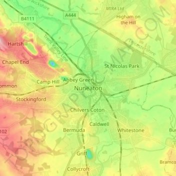
Nom : Carte topographique Nuneaton, altitude, relief.

Lieu : Nuneaton, Nuneaton and Bedworth, Warwickshire, England, CV11 5AB, United Kingdom (52.48462 -1.50845 52.56462 -1.42845)

Altitude moyenne : 101 m

Altitude minimum : 39 m

Altitude maximum : 172 m

Autres cartes topographiques

Cliquez sur une carte pour visualiser sa topographie, son altitude et son relief.

Nuneaton Common

United Kingdom > England > Warwickshire > Nuneaton and Bedworth

Nuneaton Common, Whittleford, Nuneaton and Bedworth, Warwickshire, England, United Kingdom

Altitude moyenne : 127 m

Ash Green

United Kingdom > England > Warwickshire > Nuneaton and Bedworth > Ash Green

Ash Green, Nuneaton and Bedworth, Warwickshire, England, CV7 9AQ, United Kingdom

Altitude moyenne : 111 m

Horeston Grange

United Kingdom > England > Warwickshire > Nuneaton and Bedworth

Horeston Grange, Nuneaton and Bedworth, Warwickshire, England, CV11 6YL, United Kingdom

Altitude moyenne : 90 m

Exhall

United Kingdom > England > Warwickshire > Nuneaton and Bedworth

Exhall, Nuneaton and Bedworth, Warwickshire, England, CV7 9DJ, United Kingdom

Altitude moyenne : 101 m

Bedworth

United Kingdom > England > Warwickshire > Nuneaton and Bedworth

Bedworth, Nuneaton and Bedworth, Warwickshire, England, CV12 9DQ, United Kingdom

Altitude moyenne : 105 m

Bulkington

United Kingdom > England > Warwickshire > Nuneaton and Bedworth

Bulkington, Nuneaton and Bedworth, Warwickshire, England, CV12 9NN, United Kingdom

Altitude moyenne : 107 m