
Carte topographique Lydham
Cliquez sur la carte pour afficher l’altitude.
À propos de cette carte
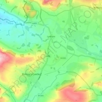
Nom : Carte topographique Lydham, altitude, relief.
Lieu : Lydham, Shropshire, England, United Kingdom (52.47997 -3.03671 52.53198 -2.94722)
Altitude moyenne : 202 m
Altitude minimum : 129 m
Altitude maximum : 338 m
Autres cartes topographiques
Cliquez sur une carte pour visualiser sa topographie, son altitude et son relief.
Minton
United Kingdom > England > Shropshire > Church Stretton > Little Stretton
Altitude moyenne : 272 m