
Carte topographique Newland
Carte interactive
Cliquez sur la carte pour afficher l’altitude.
À propos de cette carte
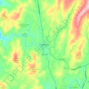
Nom : Carte topographique Newland, altitude, relief.
Lieu : Newland, Avery County, North Carolina, 28653, United States (36.04735 -81.96734 36.12735 -81.88734)
Altitude moyenne : 1 199 m
Altitude minimum : 987 m
Altitude maximum : 1 535 m
At an elevation of 3,621 feet or 1,104 metres, it is the highest county seat in the Eastern United States (based on elevations in the USGS database).