
Carte topographique Unterlängenfeld
Carte interactive
Cliquez sur la carte pour afficher l’altitude.
À propos de cette carte
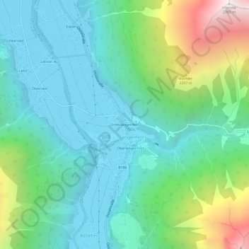
Nom : Carte topographique Unterlängenfeld, altitude, relief.
Lieu : Unterlängenfeld, Längenfeld, Bezirk Imst, 6444, Österreich (47.05518 10.94960 47.09518 10.98960)
Altitude moyenne : 1 604 m
Altitude minimum : 1 150 m
Altitude maximum : 2 954 m